|
Arctic and Antarctica
Reference:
Vasil'chuk Y.K., Ginzburg A.P.
Radial differentiation of chemical composition of cryogenic soils in the Chara river valley, north of Transbaikalia
// Arctic and Antarctica.
2023. ą 2.
P. 115-128.
DOI: 10.7256/2453-8922.2023.2.40965 EDN: HGVJAS URL: https://en.nbpublish.com/library_read_article.php?id=40965
Radial differentiation of chemical composition of cryogenic soils in the Chara river valley, north of Transbaikalia
Vasil'chuk Yurii Kirillovich
ORCID: 0000-0001-5847-5568
Doctor of Geology and Mineralogy
Professor, Lomonosov Moscow State University, Faculty of Geography, Department of Landscape Geochemistry and Soil Geography
119991, Russia, Moscow, Leninskie Gory str., 1, of. 2009

|
vasilch_geo@mail.ru
|
|
 |
Other publications by this author
|
|
|
Ginzburg Alexander Pavlovich
Graduate Student, Department of Landscape Geochemistry and Soil Geography, Lomonosov Moscow State University
119991, Russia, Leninsky Gory region, Moscow, Leninsky Gory str., 1, of. 2007
|
|
alexandrginzburg13154@yandex.ru
|
|
 |
Other publications by this author
|
|
|
DOI: 10.7256/2453-8922.2023.2.40965
EDN: HGVJAS
Received:
10-06-2023
Published:
27-06-2023
Abstract:
The subject of the study is the content of iron compounds and their radial differentiation in the profiles of cryogenic soils of the Chara River valley (Transbaikalia). The studied soils belong to post-pyrogenic permafrost gleyzems, the depths of the seasonal active‐layer of these soils are from 34 to 44 cm. Macronutrient concentrations, with the exception of Si, rarely exceed 5.0%, while the silicon content reaches 24.3%. Si is also characterized by removal from the upper part of soil profiles and accumulation in permafrost soil horizons. The highest concentrations are characteristic in the O horizons (Mg – 4.8 and Ca – 1.5 mg/kg) for a significant part of the macroelements. The trace elements, Sr and Zr are distributed vary contrastingly (from 5.0 to 29.7 and from 5.6 to 47.1 mg/kg). Values of the R coefficient from 0.3 to 0.9 indicate the initial stage of post-pyrogenic restoration of soil properties, and the active accumulation of Mg, Ca, Ti, Fe, Sr, and other elements in the upper part of oxidized-gley permafrost gleyzem observed in the profile is a sign of active restoration. The soils contain about 3.4% iron, which more than 60–75% is the silicate group of compounds (Feń). The moisture content of soils and the prevailing reducing environmental conditions contribute to the formation of monotonous distributions in their profiles, and in soils without signs of stable hydromorphism, permafrost horizons contain almost 2 times more Feox and Feextr.
Keywords:
cryogenic soils, radial differentiation, macroelements, microelements, iron compounds, profile distributions, permafrost, seasonal active layer, Chara basin, Northern Transbaikalia
This article is automatically translated.
You can find original text of the article here.
Introduction The radial differentiation coefficient (R) proposed by A.I. Perelman and N.S. Kasimov [15] is designed to study the heterogeneity of the vertical distribution of chemical concentrations in soil profiles. In contrast to the form of the profile distribution graph, which gives only a qualitative characteristic of the heterogeneity of the distribution, the radial differentiation coefficient demonstrates a quantitative assessment of the effect of soil formation on the accumulation and dispersion of individual chemicals in the horizons of the soil profile. The comparison is carried out between the horizons of the upper part of the profile affected by the processes of soil formation and the horizons of soil-forming rocks, the effect of soil formation in which is conditionally absent. Studies of profile distributions of chemical elements in cryolithozone soils are a very promising area of modern landscape geochemistry for the following reasons. Firstly, the study of the radial water migration of elements and compounds in permafrost soils can be useful from the point of view of their participation in biogeochemical cycles that have not been fully investigated in northern ecosystems.[14] Secondly, the study of soils contaminated with various chemicals, including potentially toxic ones, is relevant in connection with the economic development of the Arctic zone of Russia, where numerous industrial productions are concentrated.[1] Thirdly, a comprehensive study of the processes of soil cryogenesis, including its role in the formation of profile distributions of individual elements (for example, iron), at this stage of the development of cryopedology is among its most important tasks.[11] The Charskaya basin is one of the key areas where various studies of the cryolithozone are carried out [8,12,17], in connection with which a comprehensive study of cryogenic soils and their features is possible.[4] 1. Objects and methods 1.1. Geographical location of the research area 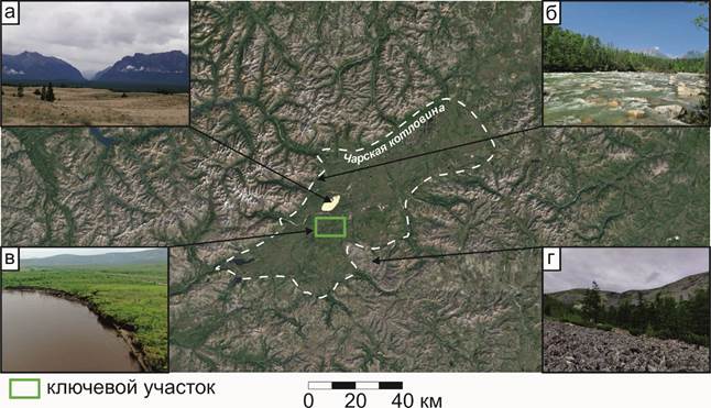
Fig. 1. The location of the key research site on the territory of the Charskaya basin and its landscape diversity: the marginal area of the Sands tract (a), the lower course of the Sredny Sakukan River (b), the valley of the Chara River (c), the kurums of the western macroscline of the Udokan ridge (d) 1.2. Physical and geographical conditions of the research area Location of the key research site The research area is located in the Kalarsky district of the Trans-Baikal Territory. The key site is located in the valley of the Chara River, in its middle course, 8 km southwest of the village. Novaya Chara, at the confluence of the Belenky Stream with the Chara (56°45’38.72’ s.w., 118°11’30.12’ v.d.) (Fig. 1). Soil sections are laid on the flat gently sloping surface of the first floodplain terrace of the Chara River with a height of 7 m above the level of the river's edge. Section Ch-22-1 is located on the right bank of the stream, section Ch-22-2 – on the left bank. On the right bank, there are signs of waterlogging of the surface, probably due to a recent natural fire that occurred here, which is evidenced by both burnt trunks of larch trees and post-pyrogenic signs in the organogenic soil horizon in this area. The left bank of the stream shows no signs of waterlogged surface. Brief physical and geographical characteristics of the area The flat part of the bottom of the Chara basin is a lowland in the valley of the Chara River, a lowland about 35 km wide stretched along its bed for 125 km. The riverine part of the basin is composed of Holocene Riverine facies of alluvial deposits (ages Q1IV – Q2IV) of various granulometric composition, composing the floodplain and low terraces of the Chara River.[7,16] The higher terraces of the left bank of the Chara are composed of late quaternary water-glacial deposits – sands and sandy loams. In places, on the territory of the basin, there are naturally moraine ridges with lake-covered depressions, and the remnants of the bedrock are chains of flat-topped hills with heights up to 200 m. In general, the height differences within the bottom of the basin are just about 200 m, in some cases it increases to 400 m. The climate of Chara is sharply continental, the average annual air temperature is about -7.8 °C, the amount of precipitation per year does not exceed 330 mm. The thickness of the snow cover in winter does not exceed 0.5 m on average due to the low amount of precipitation and strong winds. The mosaic of geomorphological elements, microclimate and vegetation cover within the basin contributes to the development of a wide variety of geocryological conditions (Table 1). The Charskaya basin is generally characterized by a high (up to 500 m) permafrost thickness of the merging type with MMP temperatures at the depths of the sole of the active layer from -6 to -4 °C. Directly on the "Belenky" site, where the CALM (circumpolar active layer monitoring) network site is located, the depth of seasonal thawing varies between 0.5 – 0.9 m.[8.17] The soil temperature at the level of the sole of the seasonal thawing layer is -4 °C.[17] Table 1. Landscape-geocryological characteristics of various types of terrain in the flat part of the Charskaya basin (according to Sergeev et al. [17]) | Platform | Geomorphological element | Height (abs.), m |
Average temperature (2006-2014), °C | | Air | Soil surfaces | At the depth of the sole STS | | "Bridge" | Boggy high floodplain of the Chary river | 700 | –6,9 | –3,4 | –5,0 | | "Belenky" | The above - floodplain terrace of the Chary river | 728 | –6,6 | –2,5 | –4,0 | | "Sands" | An array of fluttering sands | 753 |
– | –1,9 | +0,3 | The territory of the Charskaya basin belongs to the mountain-taiga high-altitude landscape belt. The lowlands here are represented by sparse forests of Kayander larch (Larix cajanderi) with undergrowth of spreading birch (Betula divaricata) and cedar elfin (Pinus pumila), as well as a powerful moss-lichen cover. When climbing into the mountains, larch woodlands gradually give way to thickets of shrubs with fragmentary moss-lichen cover, and the tops of mountain ranges often have no vegetation cover at all – loaches. In the intermountain basins of the Baikal type, common in this sector of the cryolithozone of Russia, the following high-altitude spectra of soil-landscape combinations are often observed (Table 2). The most detailed soil-landscape connections in the structure of the high-altitude belt of the inner slopes of the intermountain basins of the Baikal type are considered in the dissertation of N.A. Nogina[13], which summarized the results of 50 years soil research in the area. A more detailed and complete physical and geographical description of the research area is presented in the article by Yu.K.Vasilchuk et al.[4]. Table 2. Soil-landscape combinations characteristic of the main high-altitude landscape belts of the intermountain basins of the Baikal type (according to N.A. Nogina[13]) | High-altitude landscape belt | Height (abs.), m | Groups of plant communities | Soils | | Dry Steppe | < 800 | Dry-steppe, meadow-dry-steppe | Chestnut (including meadow-chestnut), salt marshes, salt marshes sorovye | | Raznotravno-cereal | 800-1000 | Meadow-steppe, real steppes, lush meadows, dry steppe | Powdery-carbonate chernozems, low- and carbonate-free, meadow-chernozem, meadow and permafrost-meadow, meadow salt marshes, salt marshes |
| Gornolesnoy | 1000-1200 | Mixed mountain forests | Podzolic, mountain permafrost sod-taiga | | Gornotaezhny | 1200-1400 | North (Upper) Taiga, Middle Taiga, South Taiga | Mountain (including turf) permafrost-taiga, permafrost-taiga (including podzol), podzols illuvial-ferruginous, podzolic, permafrost-swamp | | Loach | > 1400 | Mountain-tundra, mountain-meadow | Goltsovo-wasteland, mountain-tundra, mountain-meadow (subalpine) | 1.3. Field methods of work Soil and geochemical studies at the key site "Belenky" were carried out in July 2022. The seasonally thawed soil layer was tested with plastic knives. The mass of each sample from the genetic horizons of soils was 250-500 g. Permafrost rocks were tested using an electric drill. 1.4. Laboratory methods of work The acidity of water extract (pH) from soils and the content of easily soluble salts in it (TDS, mg/l) were determined using laboratory stationary potentiometer (hydrogen-selective electrode) and METTLER-TOLEDO conductometer by potentiometric and conductometric methods, respectively. The electrical conductivity of the soil extract (EC, µs/cm) was calculated as twice the content of easily soluble salts (EC = TDS*2). The total content of organic carbon (Coc) in soils was measured by the method of I.V. Tyurin with photometric termination as a result of redox titration of bichromate-potassium extract from the soil with Mora salt in the presence of 5-6 drops of phenylanthranilic acid. The granulometric composition of soils was determined by laser granulometry on the Fritsch Analysette-22 granulometer (Germany) during pretreatment with sodium pyrophosphate and ultrasonic disintegration of colloidal particles.
The group composition of iron, including non-silicate, oxalate–soluble and organic-matter-related groups of compounds, was studied by parallel extraction according to the scheme of S.V. Zonn: non-silicate iron (Fe hc) is displaced from the soil extract in a solution of sodium salts by adding dry powder of sodium dithionite by the Mera-Jackson method, oxalate-soluble (Fe acs) - reagent Tamma with a pH of 3.8 according to the Tamma method, extracted or bound to organic matter (Fe extra) – potassium pyrophosphate according to the Bascombe method. The technique is described in detail in [19], by Yu.N. Vodyanitsky and N.P. Kirillova[6]. 1.5. Radial differentiation coefficient To analyze the radial differentiation of soil profiles, the radial differentiation coefficient R.[15] was used. It is calculated by the formula Ri = Ci mountains/Ci pores, where Ci mountains is the content of chemical element i in the soil horizon, Ci pores are the content in the rock, where the influence of soil–forming processes on the chemical composition is conditionally negligible. 2. Results 2.1. Cryogenic soils and their physico-chemical properties The soil profiles presented on the terrace of the Chara river have a number of diagnostic features that allow them to be attributed to the trunk of postlitogenic soil formation, the department of gleev soils, the type of gleezems, as well as to assign their names to the subtypes post-pyrogenic and permafrost. The capacity of the seasonally thawed layer of these soils is 34 (section Ch-22-1 – the right bank of the Belenky creek, swampy surface) and 44 (section Ch-22-2 – the left bank of the Belenky creek, the surface without signs of waterlogging) cm, respectively. The upper parts of both considered profiles are characterized by dark brown, weakly and medium-laid bedding horizons, in which, upon close examination, small (less than 0.5 cm) and large (up to 2 cm) embers, as well as remnants of charred sediment fragments, are observed - signs of a pyrogenic process that sharply and extracontinental regions of Siberia in one or more to a different extent, it affects the entire soil cover, which is why A.P. Chevychelov introduced a post-pyrogenic subtype into the classification of post-lithogenic soils on a mineral substrate.[20] Below in the soil profiles there is a change of the organogenic horizon to the mineral gley (G), which is distinguished by the contrast of redox conditions, diagnosed by bright red or light gray-brown with yellowish colors, indicating the predominance of the trivalent form of iron over the divalent. Apparently, the air penetrating through the O horizons creates an oxidizing environment here, but deep horizons (CG) do not allow air to pass through due to higher humidity and weighted granulometric composition, as a result of which the content of the predominant form of Fe 2+ increases. Permafrost horizons of soils, the upper boundaries of which are located at depths of 34 and 44 cm from the surface, respectively, are almost similar in color and granulometric composition to the overlying ones. They are characterized by a massive cryogenic texture with a low total ice content (? 30%). 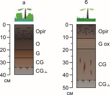
Fig. 2. Profile structure of soils of the valley of the Chary river: post-pyrogenic permafrost (Ch-22-1) (a), oxidized-gley post-pyrogenic permafrost (Ch-22-2) (b) According to the classification and diagnostics of soils in Russia[9], the studied soils were given the names: post-pyrogenic permafrost gleezem (Fig. 2a) and oxidized-gley post-pyrogenic permafrost gleezem (Fig. 2b). The gleezems of the Chara Valley belong to acidic soils with a pH of 3.9 to 5.1 units. The pH values are characterized by the lowest values in the upper part of the profile and further increase with depth. On average, the Ch-22-1 gleezem profile is more acidic (3.9–4.5) than the Ch profile-22-2 (4,9–5,1). The content of organic carbon in soils reaches a maximum of 8.7% in the organogenic horizon of the section of post-pyrogenic permafrost (Ch-22-1) and 6.8% in the section of oxidized-gley post-pyrogenic permafrost (Ch-22-2). Lower in the profile, the amount of C–org in the soil horizons decreases by 4.5-5.5 times, and in the horizons of MMP (CG?) in both cases there is a small accumulation of C-org, in comparison with the overlying unfrozen horizons. 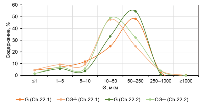
Fig. 3. The content of granulometric fractions of a certain diameter (microns) in thawed (G) and permafrost (CG?) horizons of the gleezems of the valley of the Chary River, % According to the content of physical clay, the studied profiles of gleezems were classified as light–loamy (the content of particles of physical clay in the profile of post–pyrogenic permafrost gleezem - 23.5–23.7%) and sandy loam (in the profile of oxidized–gleezem post-pyrogenic permafrost - 11.2-14.8%), according to the classification of N.A. Kachinsky. Fig. 3 shows that permafrost horizons on average have a slightly heavier granulometric composition than seasonally thawed ones. The predominant fraction in them is 10-50 microns, whereas in seasonally thawed mineral horizons the most concentrated fraction is 50-250 microns. 2.2. Gross elemental composition of soils
The specifics of the elemental composition of cryogenic soils of the Chary River valley are approximately comparable Fe and Mg contents in them of about 2-4%, as well as reduced concentrations of Ti and Mn – their contents in soil profiles are always below 1% (Fig. 4). In addition, among the trace elements, Sr and Zr differ the most among the studied concentrations, the contents of which are they reach 29.7 and 47.1 mg/kg, respectively. 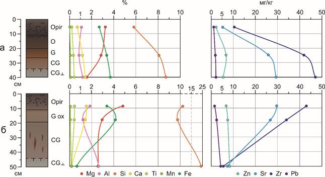
Fig. 4. Profile distributions of chemical element contents in the profiles of the gleyozems of the Chary River valley: post-pyrogenic permafrost gleyozem (Ch-22-1) (a), oxidized-gley post-pyrogenic permafrost gleyozem (Ch-22-2) (b) The Si contents in the studied gleezems vary significantly, their concentrations range from 5.8 to 8.7% and from 8.1 to 24.3%. There is an increase in Si concentrations to the lower part of the profiles of both soils. No other macronutrient is characterized by a similar trend in the profile distribution, for example, Al and Fe with similar geochemical properties are accumulated mainly in the upper parts of the profiles – in the surface organogenic horizon. Below the profile, their content, as well as Mg and Ca content, sometimes decrease by 2-8 times. Ti and Mn, whose concentrations in the studied soils are small, are also characterized by a slight variation within the profile – from 0.2 to 0.4% (Ti) and from 0.03 to 0.1% (Mn). Sr and Zr demonstrate different profile distributions in two soils: if in the Ch-22-1 profile they accumulate in deep horizons, including permafrost (Fig. 4a), then in the Ch-22-2 profile everything happens exactly the opposite. Zn and Pb in the profile are distributed very evenly, while lead concentrations are the lowest among the microelements considered – from 1 to 4.5 mg/kg. 2.3. Radial differentiation of soil chemical composition If the horizons of MMP are taken as horizons of soil-forming rocks, there is an enrichment of organogenic pyrogenic horizons Mg (R = 2.1) in the Ch-22-1 profile (Fig. 5a) and Mg, Ca, Ti, Fe, Sr and Zr in the Ch-22-2 profile (Fig. 5b). Removal from the upper parts of both soil profiles is characterized by Al, Si, Mn and Pb. The coefficients R of these elements in the permafrost part of soils vary from 0.3 to 0.9. The contrast of profile distributions of elements in soils differs as follows: If only Mg differs in the contrast profile distribution in the Ch-22-1 profile, then in the Ch-22-2 profile, most of the elements are distributed in contrast within the profile – Mg, Ca, Ti, Fe, Sr and Zr, the enrichment of soil profiles with which is twofold or more (for example, R Ca = 9.8). The horizons of permafrost rocks, in comparison with the overlying thawed horizons, are enriched with most of the elements, except Mg. Probably, as a result of the fire that took place about 3 years ago, the mobilization of these elements and their removal to the lower part of the soil profile occurred, and the processes of self-healing of soils have not yet reached the stage after which the initial content of elements is reached. 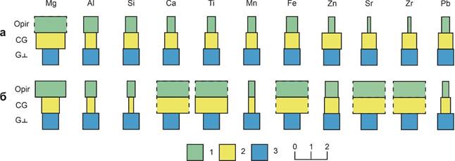
Fig. 5. Coefficients of radial differentiation (R) of chemical elements in cryogenic soils of the Chary River valley: seasonal-thawed horizons (1), cryogenic seasonal-thawed horizons (2) and permafrost horizons (3) In the profile of the oxidized-gley post-pyrogenic permafrost, the surface of which was traversed by fire 28-30 years ago, on the contrary, there seems to be that stage of post-pyrogenic soil restoration at which the concentrations of most of the chemical elements reach a temporary maximum, after which they are again involved in radial migration cycles and the formation of radial distributions will begin again. 2.4. Group composition of iron compounds The analysis of the group composition of iron compounds showed that silicate compounds of iron (Fe c) are predominant in the structure of the gross content of Fe, its share varies from 0.6 to 0.75 of the total iron contained in soil horizons. The proportion of non-silicate compounds (Fe hc) is significantly lower than silicate compounds, their absolute content ranges from 0.3 to 0.59% (Table. 3), and there is no significant decrease or obvious differentiation between thawed and frozen soil horizons. Post-pyrogenic permafrost gleezem (section Ch-22-1) is characterized by an almost equivalent content of Fe ox and Fe extra, both between these fractions and between soil horizons – 0.07–0.08, and for section Ch-22-2, on the contrary, the predominance of oxalate-soluble iron over the extracted one is almost 2 times, and also in both cases, an almost twofold increase in the contents of these compounds during the transition from the horizons of the STS to the MMP (Table 3). It is likely that the waterlogging of that part of the surface of the above-floodplain terrace and the predominance of restorative conditions in the gleezem profile in the Ch-22-1 section, as also evidenced by the morphological properties of the profile of this soil, led to the equalization of the contents of Fe oxo and Fe extra in depth. Table 3. Total iron content (Fe val), as well as concentrations of its silicate (Fe c), non-silicate (Fe hc), oxalate-soluble (Fe ox) and extractable (Fe extra) compounds (%) in the gleezems of the valley of the Chary River | Sample | Horizon |
Depth, cm | The content of iron compounds, % | | Fe shaft | Fe with | Fe ns | Fe oks | Fe extra | | Section Ch-22-1. Post - pyrogenic permafrost gleezem | | Ch-22-1/2 | G | 20(25)-26(30) | 3,36 | 3,06 | 0,30 | 0,08 | 0,08 | | Ch-22-1/3 | CG? | 34… |
3,67 | 3,25 | 0,41 | 0,08 | 0,07 | | Section Ch-22-2. Gleyozem oxidized-gley post-pyrogenic permafrost | | Ch-22-2/2 | Gox | 11(13)-18(25) | 4,14 | 3,55 | 0,59 | 0,13 | 0,06 | | Ch-22-2/3 | CG? | 44… | 0,62 | 0,29 | 0,33 |
0,32 | 0,12 | 3. Discussion The highest concentrations in the soils studied by us are characterized by Si, Fe and Mg, their average contents are 11.1, 3.0 and 3.0%, respectively. These elements are distributed most contrastingly in the soil profiles, the values of R Mg, Si, Fe = 1.8–2.1, 0.3–0.9 and 0.7–6.7, respectively. According to A.B.Gyninova, Si (70% vs. 73.1–75%), Al (12.8% vs. 13.3–13.7%) and K (2.9% vs. 3.1–3.3%) are most significantly removed from the pyrogenic horizons of the Baikal soils under coniferous forests in the delta of the Selenga River, and Mn (0.1% vs. 0.04–0.1%) and Ca (1.9% vs. 1.7%). The profile distribution of Ca is also very contrasting, the R-coefficient of which in the studied soil horizons ranges from 0.5 to 9.8. The upper part of the soil profile Ch-S-22-1 is depleted of Ca, Ti and Fe (R = 0.5 – 0.9), and in the soil Ch-22-2, the upper part of the profile, on the contrary, enriched with these macronutrients (R = 2.0 – 9.8). Trace elements, with the exception of Rb, Sr and Zr, differ in similar trends of profile distributions in both soil profiles. The upper parts of the soil profiles Ch-22-1 and Ch-22-2 are depleted of Zn, Y, Nb and Pb, and the recently burnt horizon O is more depleted of them than the fire passed 28 years ago O pir. If Rb is distributed relatively weakly in the Ch-22-1 soil profile (R = 0.8), then Sr and Zr, on the contrary, are very weakly fixed in the upper part of the profile of this soil, especially in the surface organogenic horizon O (R = 0.2). In the second profile, on the contrary, the values of the R coefficient show a strong accumulation of Rb, Sr and Zr in its upper part. Here they have values of 3.1 (Rb), 3.6–4.0 (Sr) and 6.1–7.7 (Zr). S.B. Sosorova and co-authors[18] found that under the influence of grass-roots forest fires, the gross contents and concentrations of mobile forms of Zn, Cu, Pb in the soil layer with a depth from 0 to 40 cm, as well as the content of Zn and Pb in plant organisms on burns. Among the studied elements, the degree of intensity of capture and accumulation is distributed as follows: Pb, Cr – average capture, Cd, Co, Ni – average accumulation, Zn, Cu – average and intensive accumulation. Here the results obtained by us contradict the data of the work of Sosorova et al.[18], since it demonstrates the removal of Zn and Pb from pyrogenic horizons with different degrees of activity (R Zn = 0.4–0.8 and R Pb = 0.5–0.4). Yu.N. Krasnoshchekov[10] also noted that post-pyrogenic interlayers and horizons of such profiles differ significantly from natural unburned analogues in terms of elemental composition, ash content of organic matter. The bedding horizons of sandy soils in the pine forests of this region as a whole are characterized by high concentrations of trace elements and their weak removal. Zn and Cd are concentrated most intensively in the litter, while Pb, Cu, Co and Ni accumulate weaker. Among the studied elements, an increase in the concentrations of Zn, Co, Cd and Pb is noted in the post-pyrogenic horizons of soils, and Cu and Ni are characterized by a decrease in concentrations after the passage of a fire. Nevertheless, the author notes that in addition to fires, the elemental composition can be influenced not only by fire, but also, to no lesser extent, by the geochemical situation of the territory – in particular, the rate of water migration and biological absorption. The relatively low contents of non-silicate iron in the profiles of the studied soils indicate, firstly, the predominantly light (sandy and sandy loam) granulometric composition of soil horizons, mainly composed of alluvial material with a predominance of iron aluminosilicates, and secondly, that the characteristic time of soil formation for this feature was repeatedly exceeded. Relatively high (up to 0.32%) concentrations of Feox indicate that the transformation processes of iron forms are slowed down in the horizons of MMP soils. Similar results were obtained in some earlier studies of the authors in various areas of the cryolithozone of Yakutia[2] and Bolshezemelskaya tundra[3]. In addition, the soil hydromorphism resulting from the occurrence of MMP close to the surface determines relatively high (up to 0.08%) Fe oxides in the soil horizons in the swampy area of the Chara terrace. Yu.N. Vodyanitsky and co-authors came to similar conclusions about the influence of soil hydromorphism on the group composition of iron.[5] 4. Conclusion Radial differentiation coefficients (R), designed to assess the heterogeneity of profile distributions of chemical element contents in soils, are rarely used in the study of cryogenic soils in permafrost landscapes of the cryolithozone. The authors studied the contents and profile distributions of macro- and microelements in the post-pyrogenic permafrost gleezems in the valley of the Chara River in the bottom of the Chara basin. With the help of standard laboratory techniques, the pH, EC, the content of organic matter and the granulometric composition of the studied soils were studied. The gross contents of chemical elements were measured by the XFA method. The following ranges of element contents in the studied soils were established: Mg (1.6–4.8%), Al (0.9–2.6%), Si (5.8–24.3%), Ca (0.2–1.5%), Ti (0.2–0.4%), Mn (0.03–0.1%), Fe (0.6-4.1%) Zn (8.5–2.0 mg/kg), Sr (5.0–29.7 mg/kg), Zr (5.6–47.1 mg/kg) and Pb (1.0–4.5 mg/kg). Profile distributions of Si are characterized by an increase in its concentrations with the depth of the soil. Fe, Al, Ca and other elements are characterized by accumulation in the surface organogenic horizons of soils. Elements such as Ti, Mn and Pb practically do not vary in soil profiles. The removal of most of the chemical elements, except Mn (R Mn reaches 2.1), is presumably due to the fact that about 3 years ago the soil surface was traversed by a natural fire, which caused the mobilization of most of the elements contained in the litter, and the process of self-healing of soils has not yet reached the stage after which the characteristic concentrations they return to their original state. On the contrary, in the upper part of the profile of the oxidized-gley post-pyrogenic permafrost, maxima of concentrations of some elements are observed, the R values of which exceed 2.0 or more, which indicates an active stage of post-pyrogenic restoration of soil properties passed by fire about 30 years ago.
According to the group composition of iron compounds, the studied soils are close to many tundra and taiga soils, including those within the continuous and insular cryolithozone. There is a more monotonous profile distribution of oxalate-soluble and extractable iron compounds in soil with high humidity and predominance of reducing environmental conditions. Acknowledgements: The authors express their gratitude to D.O. Sergeev, Ph.D., Head of the Geocryology Lab of the Institute of Geoecology named after E.M. Sergeev of the Russian Academy of Sciences, and V.A. Palamarchuk, Ph.D., GAU YANAO "Scientific Center for Arctic Studies" for assistance in conducting field work, as well as D.B.N., Professor of the Faculty of Geography M.V. Lomonosov Moscow State University M.I. Gerasimova for help and advice on the rules of classification and diagnostics of soils, S.N.S., Ph.D. N.A. Budantseva and M.N.S. J.Y. Vasilchuk for discussing the results.
References
1. Alexeev A.I., Abakumov E.V. (2019). Heavy metals in soils of natural and urban landscapes of the Yamalo-Nenets Autonomous Okrug. Scientific Bulletin of the Yamalo-Nenets Autonomous Okrug, 89–92. (in Russian). doi:10.26110/ARCTIC.2019.102.1.012
2. Vasilchuk Yu.K., Ginzburg A.P. (2023). Lateral and radial differentiation of the chemical composition of cryogenic soils in the Vilyui river valley, Central Yakutia. Arctic and Antarctic, 1, 65–84. (in Russian). doi:10.7256/2453-8922.2023.1.40034
3. Vasilchuk Yu.K., Ginzburg A.P. (2023). Lateral and radial differentiation of the geochemical composition of cryogenic soils of the Khanovei educational and scientific testing ground, Bolshezemelskaya tundra. Arctic and Antarctic. No. 1. P. 88–114. (in Russian). doi:10.7256/2453-8922.2023.1.40136
4. Vasilchuk Yu.K., Ginzburg A.P., Budantseva N.A., & Vasilchuk J.Yu. (2022). Cryogenic soils in the valley of the river. Enchantment, Transbaikalia. Arctic and Antarctic. No. 3. P. 54–91. (in Russian). Retrieved from https://doi.org/10.7256/2453-8922.2022.3.38689
5. Vodyanitsky Yu.N. (2010). Iron compounds and their role in soil protection. Moscow: Dokuchaev Soil Institute of the Russian Agricultural Academy. 156 p.(in Russian).
6. Vodyanitsky Yu.N., Kirillova N.P. (2016). Using the CIE-L*a*b* system to characterize soil color. Soil Science, 2016. No. 11. pp. 1337–1346. (in Russian). doi:10.7868/S0032180X16110101
7. Geological map of the USSR. Scale 1:200,000. Bodaibo series. Sheet O-50-XXIX. (1975). Author V.S. Shulgin. Ed. A.M. Leites. All-Union Aerogeological Research and Production Association "Aerogeology" of the Ministry of Geology of the USSR. (in Russian).
8. Zabolotnik S.I., & Klimovsky I.V. (1966). Seasonal thawing and freezing of soils in the Charskaya depression. Geokryological conditions of the Zabaikalsky north (pp. 162–171). Moscow: Nauka. (in Russian).
9. Classification and diagnostics of Russian soils. Smolensk: Oikumena, 2004. (in Russian).
10. Krasnoshchekov Yu.N. (2009). Post-pyrogenic transformation of soils of pine forests in the southwestern Baikal region. Bulletin of KrasGAU, 9, 60–65. (in Russian).
11. Soil cryology. (2019). Moscow: RAS publ. (in Russian).
12. Anisimov O.A., Anokhin Yu.A., Lavrov S.A., Malkova G.V., Pavlov A.V., Romanovsky V.E., Streletsky D.A., Kholodov A.L., & Shiklomanov N.I. (2012). Methods for studying the consequences of climate change for natural systems: Chapter 8. Continental permafrost (pp. 301–359). VNIIGMI Publishing House. (in Russian).
13. Nogina N.A. (1964). Soils of Transbaikalia. Moscow: Nauka. (in Russian).
14. Fundamentals of biogeochemistry. (1998). In Proc. manual for geogr., biol., geologist., S.-x. special universities. - Moscow: Higher. school. (in Russian).
15. Perelman A.I., & Kasimov N.S. (1999). Landscape Geochemistry: Textbook. Moscow: Astreya. (in Russian).
16. Natural conditions for the development of the north of the Chita region. (1962). Moscow: Publishing house of the Academy of Sciences of the USSR, M-117V. 124 p. (in Russian).
17. Sergeev D.O., Stanilovskaya Yu.V., Perelshtein G.Z., Romanovsky V.E., Bezdelova A.P., Aleksyutina D.M., Bolotyuk M.M., Khimenkov A.N. , Karpalova V.N., Motenko R.G., & Maleeva A.N. (2016). Background geocryological monitoring in northern Transbaikalia. Earth's Cryosphere (Kriosfera Zemli) (pp. 24–32). V. XX. No. 3. (in Russian).
18. Sosorova S.B., Merkusheva M.G., & Ubugunov L.L. (2013). Pyrogenic change in the content of trace elements in soils and plants of pine forests in Western Transbaikalia. Siberian Ecological Journal, 5, 661–674. (in Russian).
19. Vorobyov L.A., ed. (2006). Theory and practice of chemical analysis of soils. Moscow: GEOS. (in Russian).
20. Chevychelov A.P. (2002). Pyrogenesis and post-pyrogenic transformations of the properties and composition of permafrost soils. Siberian Ecological Journal, 3, 273–278. (in Russian).
Peer Review
Peer reviewers' evaluations remain confidential and are not disclosed to the public. Only external reviews, authorized for publication by the article's author(s), are made public. Typically, these final reviews are conducted after the manuscript's revision. Adhering to our double-blind review policy, the reviewer's identity is kept confidential.
The list of publisher reviewers can be found here.
The subject of the study is, in the author's opinion, the patterns of radial differentiation of the chemical composition of cryogenic soils on the example of the valley of the Chara River, Northern Transbaikalia. Research methodology, the article indicates the use of field methods, determination of acid extraction PH, chemical analysis of easily soluble salts, organic carbon content, group composition of iron and others obtained as a result of laboratory chemical analysis of macronutrient composition in frozen rocks, as well as analysis of literature data. Judging by the illustrative material, the author undertook expeditionary field research methods, followed by desk processing. The relevance of the topic raised is unconditional and consists in obtaining information about the profile distributions of chemical elements in cryolithozone soils – a very promising area of modern landscape geochemistry, since the study of radial water migration of elements and compounds in permafrost soils can be useful from the point of view of their participation in biogeochemical cycles that have not been fully investigated in northern ecosystems, secondly the study of contaminated soils is relevant in connection with the economic development of the Arctic zone of Russia, where numerous industrial productions are concentrated, thirdly, a comprehensive study of the processes of soil cryogenesis, including its role in the formation of profile distributions of individual elements (for example, iron), at this stage of the development of cryopedology is among its most important tasks for the theory cryolithogenesis. The scientific novelty lies in the attempt of the author of the article, based on the conducted research, to conclude about the content and profile distribution of macro- and microelements in the post-pyrogenic permafrost gleezems in the valley of the Chara river in the bottom of the Chara basin, pH, EC, Sorghum content and granulometric composition of the studied soils, gross contents of chemical elements were studied. This is an important addition in the development of geocryology. Style, structure, content the style of presentation of the results is quite scientific. The article is provided with rich illustrative material reflecting the process of ice formation in the soil. Of the directions given by the author, it should be noted a particularly interesting moment in terms of the group composition of iron compounds, the studied soils are close to many tundra and taiga, including within the continuous and insular cryolithozone. The article contains a variety of interesting illustrative material in the form of tables, figures and diagrams. The bibliography is very exhaustive for the formulation of the issue under consideration, but does not contain references to normative legal acts and methodological recommendations on the geochemical analysis of soil features. The appeal to the opponents is presented in identifying the problem at the level of available information obtained by the author as a result of the analysis. Conclusions, the interest of the readership in the conclusions there are generalizations that made it possible to apply the results obtained. The target group of information consumers is not specified in the article.
|

 Eng
Eng


