|
DOI: 10.7256/2310-8673.2022.4.37724
EDN: RNLSKA
Received:
21-03-2022
Published:
30-12-2022
Abstract:
The work is devoted to the identification of existing imbalances in the spatial structure of the city and the assessment of reserves for improving the efficiency of spatial organization, primarily due to the development of the framework of the city as a stable structure-forming part of the spatial system of the city, characterized by a high degree of development. The subject of the study is the types of territories forming the framework of the city. The definition of the role and potential of individual territories is carried out by means of modeling using the methodology of constructing a territorial and communication model of the city of O.A. Bayevsky on the basis of the frame-tissue theory of A.E. Gutnov. The simulation results are compared with the analysis of mobile operator data on daily migrations of people in the city. As a result of the modeling, the territories were typified, the framework and fabric of the city were identified, as well as territories with disproportions of saturation with points of attraction and connectivity with the population. Comparison of the results of analytical modeling and visualization of real movements of cellular subscribers during the day confirms the significant disproportions of the spatial structure of the city of Vladivostok, expressed in its monocentricity. The prospects for improving the efficiency of the spatial organization of the city are associated with the need to move away from monocentricity through the development of local centers in the city districts. Clarification of the disproportions of daily migrations by city districts allows us to confirm the need and assess the reserves for the development of new growth points and business activity. The results of the territorial-communication model are compared with the results of the unevenly-zoned model of the city developed by the author earlier, built according to the method of A.A. Vysokovsky, which allows us to determine not only the existing configuration of the city frame, but also promising territories for its development. As a result of the work, recommendations are proposed for the development of the city's framework, and appropriate generalized directions of urban planning policy are proposed for the selected types of territories.
Keywords:
urban models, spatial system of the city, city data, disproportions, the framework of the city, types of territories, matrix of spatial imbalances, matrix of transport correspondence, zoning, urban mobility
This article is automatically translated.
You can find original text of the article here.
Introduction. The goals of territorial planning are to form an urban environment favorable for human activity, sustainable socio-economic and spatial development of the city. The effectiveness of the spatial structure of the city is a significant condition for achieving these goals. Efficiency as obtaining the maximum result at minimum cost in relation to urban life is determined by the ratio of the volume and variety of goods and services and their transport accessibility for the resident population. In other words, the choice that the territory provides is a measure of the effectiveness of spatial organization [12]. The choice in this case is the spatial and temporal availability of goods and services. Effective distribution in the city structure of the main elements of urban life — housing and points of attraction (places of employment, objects of social, business and social infrastructure), reduces the average travel time in the city, reduces the load on transport infrastructure, increases the comfort and economic potential of the urban environment [22]. The founder of the system theory of the city in Russian urban planning A.E. Gutnov wrote: "The main rule of urban development is to increase the number of potential contacts (freedom of choice or exchange) while minimizing the associated costs," A.E. Gutnov [19]. On the basis of this idea, he developed a frame-fabric model of the urban planning system, which was then developed and supplemented by the territorial and communication model of O.A. Bayevsky [11, 12, 13] and the unevenly zoned model of A.A. Vysokovsky [15]. All three models are heuristic in nature and fit into the framework of A.E. Gutnov's general theory of urban development [16]. The territories of the city that offer the greatest choice and provide exchange functions — places of concentration of public facilities, places of employment, services, social contacts and at the same time have infrastructural connectivity are called the framework of the spatial system of the city. In other words, the framework of the city is a stable structure—forming part of the system, concentrating the main processes of the life of the urban population associated with a high intensity of spatial development. The framework of the city ensures its spatial and functional integrity. The parameters of the framework determine the potential of choice that the city is able to offer its residents, as the main determinant of the quality of urban life. Fabric is the main material substrate of the city, monofunctional zones that localize single types of activities. [11, 19]. In the system theory of the city, the urban planning system is considered as a dynamic, continuously developing object. In the process of cyclical development of the city, territorial expansion is replaced by structural reorganization. The increase in the size of the system should be ensured by the development of the framework, the active formation of new elements. Disproportions in the development of the city frame are the main urban planning potential and reserve for the formation of an effective spatial system of the city. The elimination of imbalances creates opportunities for further expansion of the urban planning system and the launch of a new cycle of its development. Differentiation of the framework and fabric of the city, identification and assessment of existing imbalances, determination of the role and potential of individual territories of the spatial structure of the city is carried out through modeling using the methodology of building a territorial and communication model of the city. This model is not only a theoretical tool, but has also been repeatedly used in practice in the development of territorial planning documents at the Institute of the General Plan of Moscow, for example, in the development of the general plan of Kazan [18]. Also, a territorial-communication model was built for Ufa in the research work of M.V. Viktorova [14] and A.A. Melnikov [21] in order to clarify the methodology when using quantitative methods. The purpose of this work is to identify existing imbalances in the spatial structure of the city of Vladivostok and to assess promising areas for improving the efficiency of spatial organization. For this purpose, a territorial-communication model is being built, the theoretical results of which are compared with the real picture of daily pendulum migrations according to mobile operator data, as well as with the results of an unevenly zoned model of Vladivostok, constructed and described earlier by the author of this article [25]. A brief overview of foreign models of urban systems. Models of urban systems described in foreign publications develop approaches to modeling dynamic systems based on cellular automata (CA) and agent-oriented models (AMB). These models use the principle of self-organization and are designed to describe the complexity and heterogeneity of urban systems, are used to predict land use and uneven urban growth [6, 3, 4]. The most popular model of urban growth based on cellular automata was SLEUTH, developed by Clarke et al. (1997) [4], taking into account such parameters such as slope, land use, alienation, city, transport and the shadow of the hills. The disadvantages of cellular automata are the lack of the possibility of modeling social processes. Forecasting of urban development based on the behavior of autonomous agents is carried out by agent-oriented modeling (ABM) methods [10, 5]. The disadvantages of agent-oriented models are the duration of calculations and difficulties with data preparation. A number of studies combine the methods of cellular automata and agent-oriented systems into a single model [9, 1]. Despite the growing variety of urban models based on cellular automata and agent simulations, a number of difficulties arise with the development of the use of urban "big" data in them, most of which is collected in real time. A separate direction of development is the models of gravity-discrete choice, which are static modeling of the urban structure at a certain point in time. For example, M. Batty's QUANT model [2] simulates traffic flows of various types in the context of the distribution of jobs and places of residence of the population. Based on the interdependencies between employment, population density and traffic flows of various "costs", the model predicts changes in these parameters, predicts the optimal distribution of jobs and housing.
The model of gravitationally discrete choice described by M. Batty has a lot in common with the territorial-communication model of O.A. Bayevsky, but it does not operate with such fundamental concepts from the point of view of the general theory of the city as a framework and fabric, as well as spatial development disproportions, because it has somewhat less operational capacity at the moment, but is of great interest with from the point of view of the detail of the approach to the differentiation of flows and types of employment, as well as from the point of view of technical implementation in the format of a web service[1]. Research methodology. The research is implemented using parametric (algorithmic) modeling tools in the Rhinoceros+Grasshopper software environment [23]. The algorithm formalizes methods for constructing a territorial communication model [11] based on data on the distribution of the population, points of attraction and the matrix of transport correspondence. The construction of the matrix of transport correspondence is carried out using the OSRM service [7]. Pedestrian and transport migrations of cellular network subscribers are based on data provided by the operator, processed and visualized by parametric (algorithmic) modeling methods. A more detailed description of the research methodology is provided in the following sections. Building a territorial and communication model. The territorial-communication model describes the structure of the spatial system of the city as a set of territorial units united by a complex of transport and communication links — correspondence. Each territory as an element of the system can be a source, target or intermediary of correspondence, depending on the number and types of objects located on it, and its spatial and temporal accessibility. The effectiveness of the organization of the spatial structure of the city is determined by the choice that the territory provides to the population, in other words, "the number and quality of potential contacts-interactions between objects and their consumers located within the time of comfortable accessibility of such a territorial unit and on it itself" [11]. The analysis of the effectiveness of the spatial structure of Vladivostok using the methodology of the matrices of disproportions of the territorial and communication model was carried out to assess the effectiveness of the placement of public and business buildings as places of concentration of public facilities that provide the greatest choice of places of employment, goods, services, social contacts, relative to the distribution of housing with a given configuration of the road network. The evaluation matrix of spatial disproportions is the main applied tool of the territorial-communication model [11]. The method of assessing the reserves of spatial development for the placement of public buildings and the development of centrality functions is based on a comparison of the urban development potential of the territory and the level of its urban use. Urban planning potential characterizes connectivity with the population — the position of the territory relative to the resident population, its accessibility. The level of urban use characterizes the saturation of the territory with "points of attraction" — public objects used by residents of the city That is, for each settlement unit of the city territory, an indicator of the saturation of the territory with points of attraction and an indicator of the connectivity of this territory with the population should be determined. The ratio of these indicators characterizes the role of the territory in the spatial structure of the city. The analysis of indicators was carried out for settlement quarters — relatively homogeneous territories bounded by sections of the street. The average size is 18 ha, from 1 ha to 300 ha. The principle of allocating settlement quarters is to ensure uniformity of saturation and connectivity indicators. The boundaries of the settlement blocks were determined by natural barriers (roads, railway tracks, reservoirs, terrain, etc.) and typological (various typologies of development of territories). The southern part of the Muravyov-Amursky Peninsula and the Saperny Peninsula of the Russian Island are accepted as the boundaries of the study. A total of 672 settlement quarters were allocated. The indicator of connectivity with the population is characterized by the proportion of the city's population that can reach the territory under consideration during the estimated time, and is calculated based on the results of modeling all possible potential movements in the city space based on the scheme of the existing road network and analysis of the distribution of the population. The diagram of the road network is obtained from the data of the OpenStreetMap resource. Based on this scheme, with the help of the Open Street Routing Machine (OSRM) route construction service [7], an analysis of the transport accessibility of the settlement quarters of Vladivostok was carried out and indicators of the connectivity of territories when moving by car were identified [24, 26]. The results of the connectivity analysis are influenced by the position of the territory in the structure of the city, the properties of the road network, as well as the location of the relative location of the population and various objects. The population was obtained based on open data on the living area of apartment buildings of housing companies on the website "Housing Reform" [20] and the indicator of the average housing supply of the city's population [17]. The estimated time is determined based on the calculation of normal transport accessibility. Transport accessibility is a weighted average indicator of the time required to overcome the distance between territories by car or by public transport. Normal transport accessibility is an indicator of time for which, with a given distribution of population and "points of attraction", the total areas of territories with different connectivity indicators are close to the normal distribution. For the city of Vladivostok, the estimated time of transport accessibility was 8 minutes. As a result, for each quarter, the number of people able to reach the territory in question in the estimated time is determined.
Connectivity with the population allows you to identify the most significant areas of the city. Thus, territories with a population connectivity index above the average of 66% have the greatest urban development potential. The average value separates the connected from the disconnected (Fig. 1). The indicator of the saturation of these territories with objects of attraction will reveal how much the intensity of the use of territories corresponds to their connectivity. The indicator of the density of points of attraction characterizes the intensity of the use of the territory or its "saturation". To calculate this indicator, data on "points of attraction" were used — Google map objects, a list of enterprises, places, organizations of the city. The total number of objects was 27 thousand. 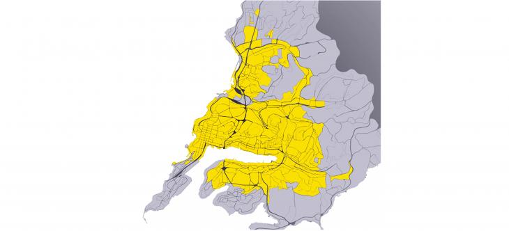
Fig. 1 Territories with connectivity with a population above the average The pairwise combination of the obtained indicators on the coordinate plane makes it possible to form a matrix: "density of points of attraction – connectivity with the population". Connectivity indicators are laid along the horizontal axis of the coordinate plane, saturation indicators are laid along the vertical axis. The division of the coordinate plane into matrix cells was carried out by calculating the mean values and the standard deviation. The calculated quarters, the indicators of which lie within the standard deviation from the average value, belong to normal territories. Territories whose indicators are outside the standard deviations experience disproportions. Thus, 16 cells of the matrix and the corresponding types of territories were determined (Fig. 2). On the basis of the disparity matrices, the effectiveness of territories was evaluated: the magnitude and direction of the disproportions for sixteen types of territories. The types of territories were determined by the territory falling into the corresponding cell of the coordination field of the matrix. For each type of territory, a certain direction of urban planning policy is recommended. The matrix makes it possible to identify the potential for the placement of "points of attraction", i.e. social and business development. Clustering of the territory according to the matrix "density of points of attraction - connectivity with the population". As a result of the work, a map of the directions of development of public buildings was obtained. The matrix "density of points of attraction – connectivity with the population" reveals the spatial structure of the city. The framework of the city, which is formed by territories with high and balanced indicators of saturation and connectivity, is a group of territories along Centennial Avenue, Nekrasovskaya Street and part of Svetlanskaya Street. Interestingly, on one side of this framework are territories with connectivity imbalances, on the other — with saturation imbalances. The entire territory of the city center is insufficiently connected with the population. Most of the territories fell into the middle cell — the territories of non-interference, which are the main fabric of the city. A more detailed analysis of the patterns of getting the indicators of quarters in a particular cell of the matrix allows you to perform clustering of the city's territories according to structural and functional properties, characterized by indicators of connectivity and saturation. 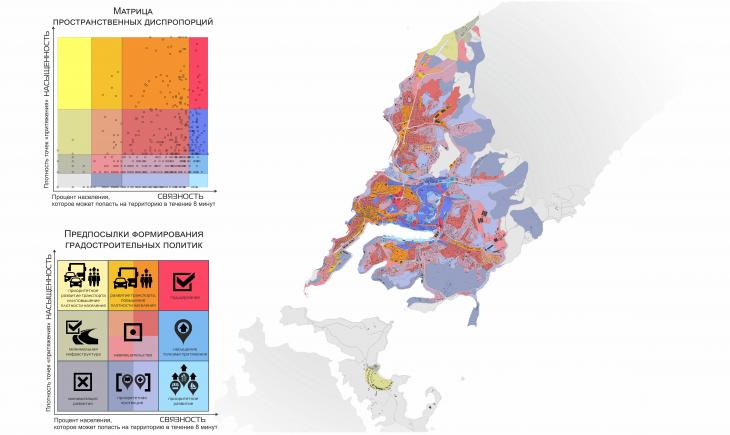
Fig. 2 Clustering of types of territories according to the matrix "density of points of attraction — connectivity with the population" and prerequisites for the formation of urban planning policy by types of territories The framework of the city. The groups of territories forming the framework of the city are characterized by high (above the standard deviation from the average value) indicators of connectivity and intensity of use of territories. Three types of territories fell into this group: balanced territories, as well as the territories closest to them with connectivity and saturation imbalances (Fig. 3). 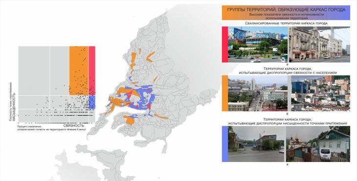
Fig. 3 Groups of territories forming the framework of the city Territories with high indicators of the density of points of attraction and connectivity with the population, "balanced city territories". Territories adjacent to the historical center and located along major transport arteries. The group with connectivity imbalances included territories oversaturated with points of attraction in comparison with indicators of connectivity with the population. These are the central territories of the city, mainly the historical center, as well as the area of the First River, the Second River and the Meadow. The indicator of population connectivity depends on the parameters of automobile accessibility and population density. Since it is impractical to increase automobile accessibility in the city center, it is necessary to find reserves for increasing population density in these territories. The territories that are the communication and connecting elements of the city's framework are highly connected, but less saturated. This group includes the territories of low-rise residential buildings, as well as territories with low-rise administrative buildings located in the valley of the First River, in the area of the Military Highway, Shilkinskaya St., the territories of the Dalzavod and port territories along Kalinin St. These territories have the greatest urban structure-forming potential. The fabric of the city. The set of "normal" territories, the indicators of which are located within the standard quadratic deviations from the average value, was divided into four groups. This allows for a more detailed analysis of the most extensive territories forming the fabric of the city (Fig. 4).
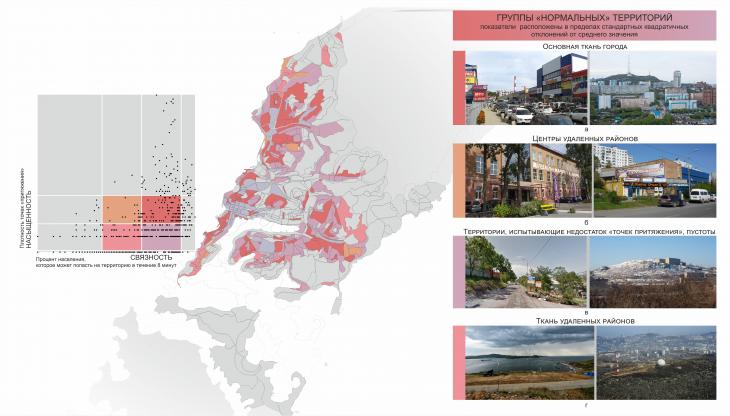
Fig. 4 Groups of "normal" city territories Territories whose connectivity and saturation indicators are above the average (Fig. 4, a) form the main fabric of the city. These are territories adjacent to the transport frame, saturated with objects of everyday household services — Postyshev, Russian, Tolstoy, Kotelnikov, Khabarovsk, Borisenko streets. Indicators of connectivity are above average, saturation is below average (Fig. 4, b) — territories that lack "points of attraction", emptiness. This group includes territories with low-rise residential buildings and territories on the tops and slopes of hills. Territories with saturation indicators above the average and connectivity below the average are identified by the centers of remote areas (Fig. 4, b) — Maritime State University named after Nevelsky on the Shkota Peninsula, the Galaktika cinema in the Quiet Bay area, the Zarya factory. The group of "normal" territories, the indicators of connectivity and saturation are below the average, is characterized as the fabric of remote areas (Fig. 4, c). Their connectivity indicators are the same as in the previous group, but the saturation is much lower. Territories with disproportions and patronage territories.The groups of territories with disproportions and patronage territories include quarters whose indicators are outside the standard deviations from the average value (Fig. 5). 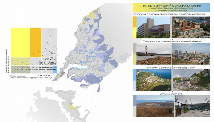 Fig. 5 Groups of city territories experiencing disproportions and patronage territories Territories with high connectivity disparities with the population (Fig.5, a) are characterized by high saturation with points of attraction, but connectivity indicators below the average are remote territories with high attendance. This group includes territories with public buildings of citywide significance on the Shkota Peninsula. The territories experiencing saturation imbalances (Fig. 5, c) are characterized by connectivity indicators above average and low density of points of attraction — port territories, as well as territories adjacent to the transport frame, but occupied by garages or low-rise buildings. Territories with small connectivity imbalances, having "normal" saturation indicators and low connectivity with the population (Fig. 5, b) — attractive coastal territories and woodlands, as well as remote residential areas. These territories cover the southern part of the Shkota Peninsula and the Saperny Peninsula on Russian Island. Territories of patronage, for which the direction of increasing the efficiency of their organization is to achieve the minimum calculated indicators of ensuring favorable living conditions of the population. It is impractical to consider them as development territories. Territories with a connectivity index below average and zero saturation (Fig.5, d) — coastal territories remote from the transport frame, as well as woodlands, suburbs. These are territories of priority patronage and minimization of development. The main results. Thus, using the analytical tool of spatial disparity matrices, based on the calculation of the parameters of population density, density of "points of attraction", connectivity with points of attraction and connectivity with the population, a territorial communication model was built for each settlement unit of the territory. Groups of territories of the framework and fabric of the city were identified, as well as territories with disproportions, which are a resource for improving the efficiency of the organization of the territory. A characteristic feature of the spatial organization of the city of Vladivostok turned out to be a pronounced disproportion with respect to the main transport artery Centennial Avenue – Nekrasovskaya Street – Golden Bridge. To the west, the territories of the city experience disproportions (lack) of saturation with points of attraction, to the east — disproportions (lack) of connectivity with the population. Since the territorial-communication model describes the structure of the city system as a set of territories united by a complex of transport and communication links, the results of analytical modeling can be compared with real population movements between territorial units identified by the data of a cellular operator. Pedestrian and transport migrations of cellular network subscribers. To analyze the dynamics of the movement of people in the space of the city of Vladivostok, data on the movement of about 200 thousand people — subscribers of the cellular network for a weekday on March 11, 2020 were used. The sample size is 241,200 people. 311 settlement zones with an average area of about 500 sq.m. were identified based on the possible accuracy of determining the subscriber's location. The boundaries of the calculated zones were determined by sections of the road network and extended linear objects. An ID is assigned for each settlement zone. In the source data table, each row contains information about the number of subscribers for a certain zone who arrived in it, dropped out or moved inside it with an interval of 1 hour. This study was carried out within the framework of non-project activities of the architectural bureau Concrete Jungle (Vladivostok). Figure 6 shows the results of the visualization of data on urban mobility. The color visualizes the disproportions: yellow indicates the predominance of displacement targets in these territories, green indicates the predominance of displacement sources. Gray tone — balanced movements. The height of the resulting geometric body characterizes the density of movements per unit of territory, volume — the number of movements. Visualization shows the peak of movements in the morning hours to the central part of the city and to the Saperny peninsula of the Russian Island. In the evening hours, the reverse process is observed in these territories, respectively.
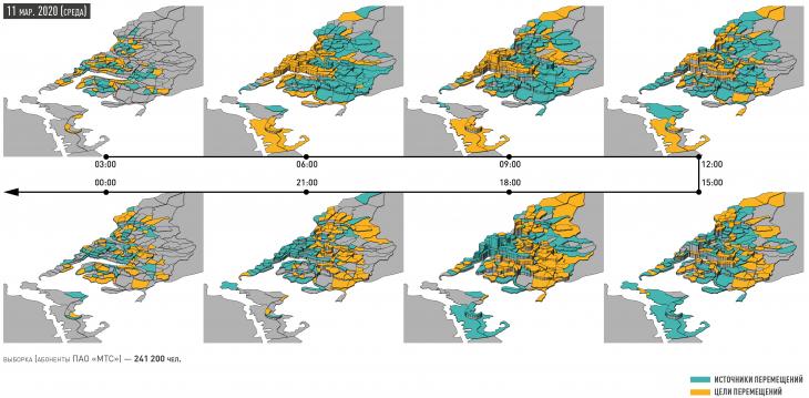
Fig. 6 Dynamics of population movement in Vladivostok during the day on March 11, 2020 The dynamics of population movements in the city of Vladivostok confirms the presence of pronounced imbalances identified through the territorial and communication model. In order to quantify the degree of monocentricity of the city, 13 vernacular districts of the city were identified: the Center, the First River, the 3rd Worker, Lugovaya–Balyaeva, Churkin, Tikhaya–Patrokl, Snegovaya, the Second River, Zarya, the Suburb, Saperny Peninsula, Russian Island (Fig. 7). Vernacular a district is a type of geographical area that is distinguished and realized by its inhabitants in the form of an image of a territory with a name and specific qualities [27]. The administrative districts of the city of Vladivostok are too large for this kind of analysis and do not have a deterministic internal core–periphery structure. 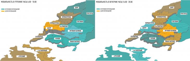
Fig. 7 Dynamics of population movement in Vladivostok during the day on March 11, 2020 in vernacular districts of the city: a — mobility in the morning hours 6:00 -10:00; b — mobility in the evening hours 16:00 -20:00 Figure 8 shows the histograms of the quantitative distribution of the directions of movement. The histograms correspond to the visualizations in Fig. 7. In the evening, the disproportions are less pronounced quantitatively, since the evening peak of movements is more distributed in time than the morning one. The largest total volumes of movements are the Center (24,267), the Second River (38,484), Lugovaya–Balyaeva (50,205) and Churkin (28,047). The greatest disproportions are observed in the Center, where the number of targets moving over the sources in the morning prevails by 36.9%. The districts of Lugovaya–Balyaeva, 3rd Rabochaya, Churkin, Tikhaya-Patrokl are the main donors for morning migrations. The most balanced area is the Second River: here the number of outgoing and incoming subscribers is almost equal. 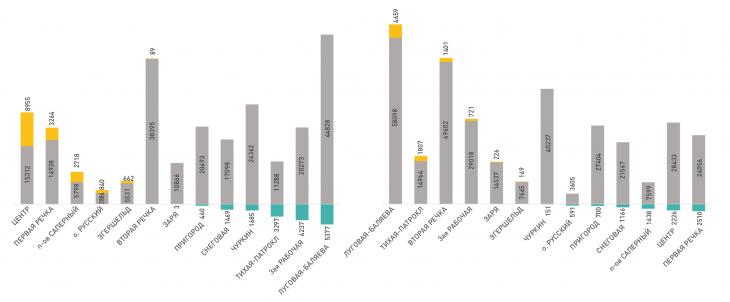
Fig. 8 Histogram of mobile network subscribers' movements between districts Visualization of mobile network subscribers' movements in the city of Vladivostok confirms the pronounced monocentricity of its structure, which indicates the need to develop local centers in the city districts through strengthening its framework, especially in the districts of Lugovaya–Balyaeva, Tikhaya–Patrokl, 3rd Working. Forecasting the development of the city frame. The uneven-zoned model of A.A. Vysokovsky allows us to judge the prerequisites for the evolutionary development of the city's framework. The results of constructing this model for the city of Vladivostok are described in the article [25]. As a result of the work, 5 levels of organization of nodes of the spatial structure of the city were identified, differentiated by the degree of diversity of types of localized objects. Within the boundaries of the identified formations, 75% of all objects of the city are concentrated on an area that makes up 19% of the urbanized territory of the city. The nodes of the unevenly-zoned model detail the structures that form the framework of the city and take into account the principle of inheritance. The evolutionary development of spatial units takes place in the direction from a smaller level of organization to a larger one. The nodes of the initial 1-2 levels have the greatest potential, which can be considered as the most promising points for improving the efficiency of the spatial organization of the city. Node groups will be enlarged as the city develops, new nodes will appear in still unstructured, but highly connected territories. Thus, the unevenly-zoned model makes it possible to identify promising boundaries of the development of the city—territory framework, in which the development of social and business development is most appropriate. The territorial-communication model through various combinations of saturation and connectivity indicators through an evaluation matrix allows us to propose individual strategies for each territorial unit separately (Table 1). 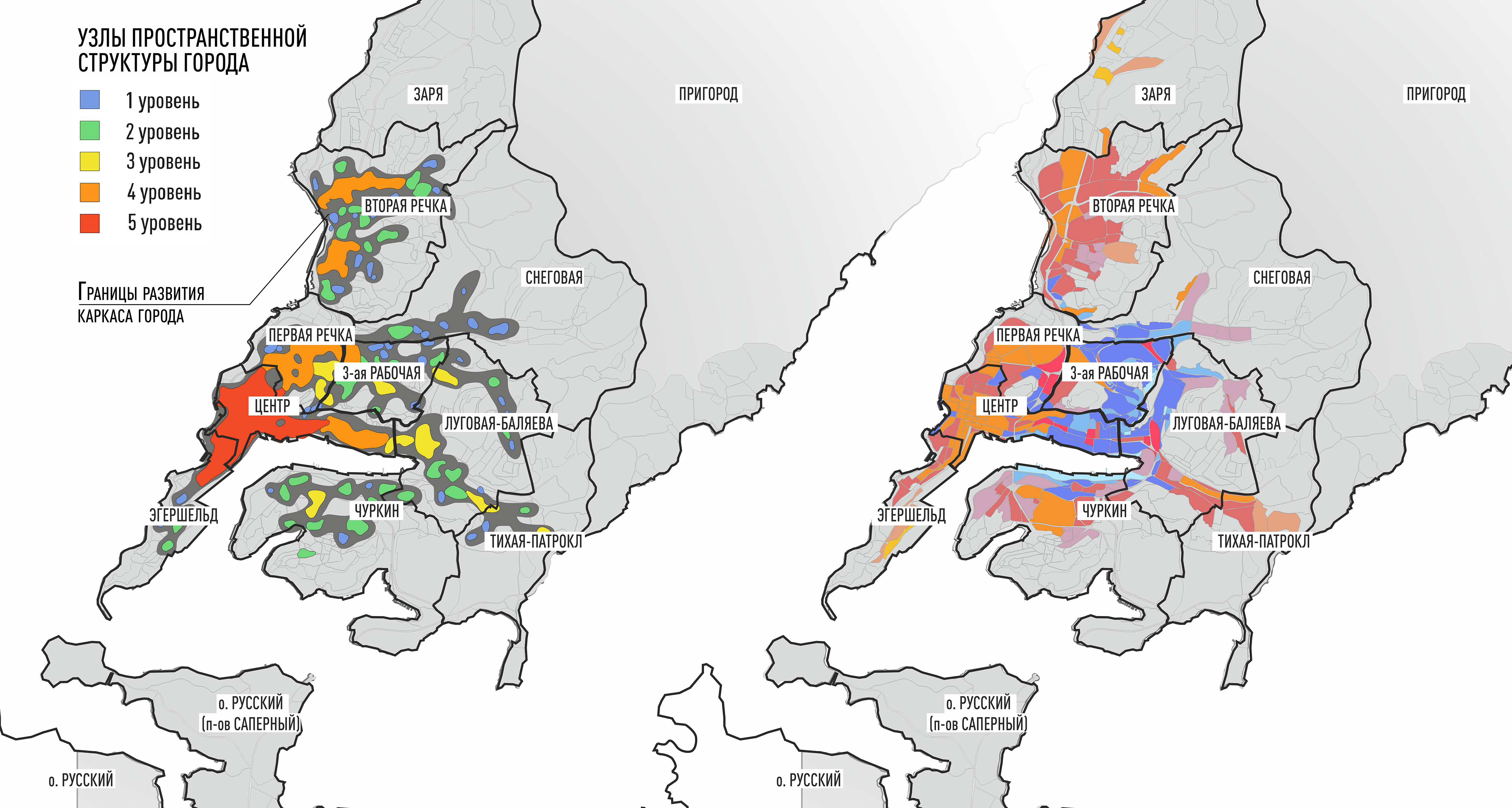
Fig. 9 Forecasting the development of the city frame: a — unevenly-zoned model, b — territorial-communication model Table 1 Recommended directions of urban planning policy for the development of the city framework as a system of local centers of districts | | Name of the type of territoryCharacteristic | Directions of urban planning policy | Balanced territories of the city frame | | | | Separate territories of the frame, saturated with enterprises and organizations | Maintaining the current role of the Territory, non-interference | | |
The territories of the frame with disproportions of saturation with points of attraction | Communication and communication elements of the framework, territories with the greatest urban development potential. | Priority placement of public and business buildings and development of territories with the function of centrality | | | | | The territories of the frame with the disproportions of connectivity with the population | Territories of the historical center of the city | 1) Increasing connectivity with the population: a) priority increase in population density in adjacent territories (additional construction of the estimated matrix "population density — connectivity with points of attraction" is required; b) priority development of transport accessibility; 2) Measures aimed at reducing the saturation of points of attraction are acceptable | | | Balanced territories are the main fabric of the city |
Residential areas adjacent to the frame, with developing commercial functions | The development of these territories should be of a complex nature, ensuring a simultaneous increase in the saturation of the territory with social and business objects, and connectivity with the population (increasing the density of the population) | | | Balanced territories — the fabric of remote areas | | | Centers of remote areas | Territories with significant social, business and social objects of urban and federal significance | 1) Increasing connectivity with the population: a) moderate increase in population density in adjacent territories (additional construction of the estimated matrix "population density — connectivity with points of attraction" is required; b) development of transport accessibility; | | | Territories lacking points of attraction, voids | Mainly industrial and warehouse areas adjacent to the frame |
Favorable territories for the development of social and business development or light industry. Accommodation is possible | The methods of the territorial-communication model not only allow to determine the position and role of the territory in the spatial structure of the city with mathematical accuracy, but also have prerequisites for the development of additional add-ons to determine quantitative indicators of the potential capacity of the frame up to the calculation of the target building density and the ratio of residential and multifunctional buildings by territories. When comparing the results of the analysis with the documents of territorial planning (General Plan, Rules of land use and development), it was found that the General Plan does not show the structure of the framework of the city. The effectiveness of the considered models exceeds the possibilities of regulation that the Rules of Land use and development of Vladivostok currently possess, which indicates the need to introduce models of frame-fabric theory into the practice of territorial planning. Relevance and scientific novelty. In this work, for the first time for the city of Vladivostok, a territorial and communication model was built and the structure-forming framework of the city was revealed, reflecting the current and actual functional state of the spatial system of the city of Vladivostok, as well as the spatial development disproportions. Comparison of the simulation results with the dynamics of daily migration of cellular subscribers further confirmed the high accuracy of the methods of the territorial communication model. The results of this work, together with the previously tested method of constructing an unevenly zoned model for the city of Vladivostok [25] and the method of zoning according to the morphotypes of the Spacematrix building density [8], are relevant analytical material that can form the basis for developing a spatial development strategy and improving solutions to the General Plan of the city of Vladivostok. But the practical use of these approaches will require clarification and updating of the original geospatial data. Conclusion. The distribution of the population as sources of correspondence and points of attraction as their goals in the structure of the city determines the effectiveness of its spatial organization for the current configuration of the road network and infrastructure. Vladivostok is experiencing pronounced spatial structure imbalances, which is confirmed by both the theoretical territorial and communication model and the real picture of daily pendulum migrations according to the mobile operator. The disproportions of Vladivostok are manifested, first of all, in the monocentricity of the city. Disproportions in the development of the city frame are the main urban planning potential and reserve for the formation of an effective spatial system of the city, the elimination of disproportions due to the development of polycentricity within the identified framework of the city creates opportunities for further expansion of the urban planning system and the launch of a new cycle of its development. The combination of methods of territorial-communication and uneven-zoned model makes it possible to identify existing and promising territories of the city frame. Within the framework of the framework, the properties of territories are heterogeneous, seven types of territory have been identified, with respect to each of which certain directions of urban planning policy should be applied. [1] http://quant.casa.ucl.ac.uk / — QUANT, a service for modeling urban systems.
References
1. Agyemang, F. (2020). Dynamic geospatial modelling and simulation of predominantly informal cities: an integrated agent-based and cellular automata model of urban growth (Doctoral thesis). https://doi.org/10.17863/CAM.52717
2. Batty M, Milton R. (2021) A new framework for very large-scale urban modelling. Urban Studies. 58(15):3071-3094. doi:10.1177/0042098020982252
3. Cao, Y., Zhang, X., Fu, Y., Lu, Z., & Shen, X. (2020). Urban spatial growth modeling using logistic regression and cellular automata: A case study of Hangzhou. Ecological Indicators, 113, 106200.
4. Clarke, KC, Hoppen, S, Gaydos, L (1997) A self-modifying cellular automaton model of historical urbanization in the San Francisco Bay area. Environment and Planning B: Planning and Design 24(2): 247–261.
5. Grignard, A., Alonso, L., Taillandier, P., Gaudou, B., Nguyen-Huu, T., Gruel, W., & Larson, K. (2018, July). The impact of new mobility modes on a city: A generic approach using abm. In International conference on complex systems (pp. 272-280). Springer, Cham.
6. Guzman, L. A., Escobar, F., Peña, J., & Cardona, R. (2020). A cellular automata-based land-use model as an integrated spatial decision support system for urban planning in developing cities: The case of the Bogotá region. Land use policy, 92, 104445.
7. Modern C++ routing engine for shortest paths in road networks. Open Source Routing Machine (OSRM). URL: http://project-osrm.org/ (accessed: 20.03.2022).
8. Potapenko, A.A., & Moor, V.K. (2020). Vladivostok City Morphology: Space Matrix as a Tool for the Urban form Analysis //IOP Conference Series: Earth and Environmental Science. – IOP Publishing, 2020. – Ň. 459. – ą. 5. – Ń. 052039.
9. Raimbault, Juste & Pumain, Denise. (2020). Spatial dynamics of complex urban systems within an evolutionary theory frame.
10. Zhao, B., Kumar, K., Casey, G., & Soga, K. (2019). Agent-based model (ABM) for city-scale traffic simulation: A case study on San Francisco. In International Conference on Smart Infrastructure and Construction 2019 (ICSIC) Driving data-informed decision-making (pp. 203-212). ICE Publishing.
11. Baevskij, O. A. (2021). Óvolution model-model evolution: coordination of city spatial development management tools // Collection of articles of the All-Russian scientific conference with international participation, dedicated to the 90th anniversary of the birth of Professor E.N. Peppers. Moscow.: Faculty of Geography of the Moscow State University. M.V. Lomonosov.
12. Baevskij, O. A. (2016). Ňĺđđčňîđčŕëüíîĺ ďëŕíčđîâŕíčĺ č ďđîĺęňčđîâŕíčĺ íŕ îńíîâĺ čńńëĺäîâŕíč˙ ďđîńňđŕíńňâĺííîé ńňđóęňóđű ăîđîäŕ: ęóđń ëĺęöčé [Territorial planning and design based on the study of the spatial structure of the city: a course of lectures]. Vysshaja shko-la urbanistiki imeni A.A. Vysokovskogo.
13. Baevskij, O. A. (2001). Ýâîëţöčîííűé ďîäőîä ę óďđŕâëĺíčţ ăđŕäîńňđîčňĺëüíűě đŕçâčňčĺě ęđóďíĺéřĺăî ăîđîäŕ. Ěîńęîâńęčé îďűň. Ăđŕäîńňđîčňĺëüńňâî Đîńńčč XXI âĺęŕ [An evolutionary approach to managing the urban development of the largest city. Moscow experience. Urban planning in Russia in the 21st century]. Collection of scientific articles RAASN. Moscow: Moskov-skie uchebniki i kartolitografija.
14. Viktorova, M.V. (2014). Âű˙âëĺíčĺ đĺçĺđâîâ ďđîńňđŕíńňâĺííîăî đŕçâčňč˙ ăîđîäŕ (íŕ ďđčěĺđĺ ă. Óôű) [Identification of the reserves of the spatial development of the city (Ufa city case study)]. Master's dissertation. Ěoscow: HSE.
15. Vysokovskij, A.A. (2005). Ďđŕâčëŕ çĺěëĺďîëüçîâŕíč˙ č çŕńňđîéęč: đóęîâîäńňâî ďî đŕçđŕáîňęĺ. Îďűň ââĺäĺíč˙ ďđŕâîâîăî çîíčđîâŕíč˙ â Ęűđăűçńňŕíĺ [Land Use and Development Rules: Development Guide. Experience of introducing legal zoning in Kyrgyzstan]. Bishkek: Ega-Basma.
16. Gostev M. (2018) On the Heuristic Nature of Evolutionary Urban Development Models. Urban Studies and Practices, vol. 3, no 1, pp. 7-22 (in Russian). DOI: https://doi.org/10.17323/usp3120187-22
17. State corporation. Fund for Assistance to the Reform of Housing and Communal Services. ReformaGKH. URL: https://www.reformagkh.ru/ (accessed: 20.03.2022).
18. Grigor'ev, O. D. (2020). Ăĺíďëŕí Ęŕçŕíč (äî 2040 ăîäŕ) [General plan of Kazan (until 2040)]. archi.ru. URL: https://archi.ru/projects/russia/15982/genplan-kazani-do--goda (accessed: 09.02.2022).
19. Gutnov A.E. (1984). Ýâîëţöč˙ ăđŕäîńňđîčňĺëüńňâŕ [The evolution of urban planning]. Moscow: Strojizdat.
20. Housing conditions. Federal State Statistics Service. URL: https://primstat.gks.ru/folder/27986 (accessed: 20.03.2022).
21. Mel'nikov, A. A., & Donguzov, K. A., & Aznabaeva, L. R. (2015). Ńčńňĺěŕ óďđŕâëĺíč˙ đŕçâčňčĺě ăîđîäńęîé číôđŕńňđóęňóđű «Óěíűé ăîđîä» [Management system for the development of urban infrastructure "Smart City"]. Archjort. ą. 1. p. 52-57.
22. Potapenko, A.A. (2018). Analysis of the effectiveness of the territorial organisation of the Shkot Peninsula, Vladivostok. FEFU: School of Engineering Bulletin. ą. 2 (35). P. 143-155.
23. Potapenko, A.A. (2021). Computational design as a means of creating a analytical and design models in architecture. Architecture and design: history, theory, innovation. – 2021. – ą. 5. – Ń. 307-311.
24. Novikov, A.V. (2018) ×ĺëîâĺę č ăîđîä. Ęĺě č ęŕę ńîçäŕĺňń˙ ăîđîäńęŕ˙ ńđĺäŕ? [Person and city. Who creates the urban environment and how?] Kommersant. URL: https://www.kommersant.ru/doc/3594351 (accessed: 25.03.2022).
25. Potapenko, A.A. Unevenly-zoned city model development (Vladivostok city case study). Architecture and Modern Information Technologies. ą. 4 (45). p. 402-415.
26. Potapenko, & A. A., Krasnov, D. A., & Moor, V. K. (2017). Computational methods in pre-design spatial structure analysis of the Vladivostok city. Architecture and Modern Information Technologies. ą. 1 (38). p. 315-328.
27. Shuvalov, V. (2015), "Regionalization in the Russian socio-economic geography: the current state and development trends", Regional'nye issledovaniya [Regional Studies], no. 3, pp. 19-29.
First Peer Review
Peer reviewers' evaluations remain confidential and are not disclosed to the public. Only external reviews, authorized for publication by the article's author(s), are made public. Typically, these final reviews are conducted after the manuscript's revision. Adhering to our double-blind review policy, the reviewer's identity is kept confidential.
The list of publisher reviewers can be found here.
Reading the text naturally begins with the title, which involves serious work of mastering. Let's reproduce it in its entirety: "The disproportions of the spatial structure of the city as a reserve for the development of the city's framework: a territorial communication model and analysis of cellular data." Not only is it a kind of rebus, but it is also a rebus that poses unsolvable questions. How and in what connection did the "imbalances" appear as a "reserve"? A euphemism? A metaphor? Unclear. Stylistically: "the disproportions ... of the structure of the city as a reserve ... of the framework of the city"; or rather, its framework. What is the relationship between the "reserve" stated in the first part and the "model" associated with it, and it, in turn, with "cellular data analysis"? But let's say the author set the task to intrigue the reader from the first lines. He succeeded. Further, the following text, however, is written in a rather academic manner — not without some flaws — or, to put it another way, specific features. In particular, the author neglects the usual structure of the introduction (following the rubrication of Relevance, Subject, Research Problem, etc.), which allows from the first lines to understand in which modality and with which subject the author operates, which problem and how he solves it. As an alternative, a "didactic" vector is proposed, leading the reader through a number of definitions — and in what connection they are given and for what purposes, it is not explained to him. Here is a brief excerpt: "In other words, the choice that the territory provides is a measure of the effectiveness of spatial organization. The choice in this case (what kind of "case" is not entirely clear, Rec.) is the spatial and temporal availability of goods and services. The effective distribution of the main elements of urban life in the city structure — housing and points of attraction (places of employment, objects of social, business and social infrastructure), reduces the average travel time around the city " (the text is accompanied by the necessary links). Well, let's say the author found it necessary to provide the reader with these valuable information from the textbook. Next, he begins to introduce him to such important categories of urban planning as "Frame" and "fabric" (again, for what purposes this is done, it is not explained). The following fragment ends the introduction: "The purpose of this work is to identify existing imbalances in the spatial structure of the city of Vladivostok and assess promising areas for improving efficiency (its?) spatial organization. To do this, a territorial communication model is being built, the theoretical results of which are compared with the real picture of daily pendulum migrations according to the mobile operator, as well as with the results of an unevenly zoned model of Vladivostok, built and described earlier by the author of this article. " (what's the point of this reference here?) The presented introduction is not entirely correct from the point of view of accepted logic; on the one hand, it lacks a number of mandatory headings (Research methodology, Scientific novelty, etc.), on the other, the manner of presentation, based on quoting and voicing a number of definitive propaedeutics, which finds an "explanation" in the final phrase, requires correction (as for the mentioned the phrase, the comments made regarding the title are applicable to it; playing with a priori complicated structures, the author risks falling the first victim of grammatical collisions, which fully applies, for example, to "the construction of a territorial communication model, the theoretical results of which (?) they are compared with the real picture of daily pendulum migrations according to the data of the mobile operator (what does this mean?), as well as with the results of the unevenly zoned model (?) of Vladivostok"; it is clear that the description correlates with fragments of somehow organized management activities - but outside of familiarity with it, the description is unclear). Style, structure, content "The most popular model of urban growth based on cellular automata was SLEUTH, developed by Clarke et al. (1997) [4], taking into account such parameters as slope, land use, alienation, city, transport and shadow from hills. The disadvantages of cellular automata are the lack of the possibility of modeling social processes. " Special innovations (cellular automata, cellular data) should be deciphered or excluded. The text of the article presents a very lengthy presentation of the experience of modeling the design image of Vladivostok in order to achieve a number of optimizations, primarily according to the criterion of transport accessibility. Here are the final lines of the text (presumably conclusions and conclusion): "Conclusion. The distribution of the population as sources of correspondence and points of attraction as their goals in the structure of the city determines the effectiveness of its spatial organization for the current configuration of the street and road network and infrastructure (distribution by itself cannot determine efficiency or non-efficiency, but can characterize it in accordance with specified criteria. Rec.). Vladivostok is experiencing pronounced spatial imbalances This is confirmed both by the theoretical territorial and communication model (a similar remark: the model itself can neither confirm nor refute the existing imbalances, Rec.) and by the real picture of daily pendulum migrations according to mobile operator data. The imbalances of Vladivostok are manifested, first of all, in the monocentricity of the city (completely incorrect, Rec.). The imbalances in the development of the city's framework are the main urban planning potential (??) and reserve (?) the formation of an effective spatial system of the city (that is, everything bad is an open field for the approval of everything good in its place? But such liberties are unacceptable in the scientific text. Rec.), the elimination of imbalances due to the development of polycentricity within the identified framework of the city creates opportunities for further expansion of the urban planning system (?) and the launch of a new cycle of its development." What has been written provides an extensive reserve of improvement and correction. Bibliography. The design of the links does not meet the requirements of the editorial board. Conclusions, the text is of interest to the readership. It is a fairly conscientiously executed compilation based on extensive experience and research projects devoted to the problems of optimizing the spatial structure of Vladivostok. The results of the described work are simply ugly; for a reader who has not devoted many years to similar studies, it will be extremely difficult to delve into the issues under consideration and grasp the essence of the proposed methods and solutions (as well as the logic of the author). Conclusion: the work generally meets the requirements for scientific presentation, but stylistically and especially structurally requires refinement, after which it is possible to re-consider the issue of its publication.
Second Peer Review
Peer reviewers' evaluations remain confidential and are not disclosed to the public. Only external reviews, authorized for publication by the article's author(s), are made public. Typically, these final reviews are conducted after the manuscript's revision. Adhering to our double-blind review policy, the reviewer's identity is kept confidential.
The list of publisher reviewers can be found here.
The article presented for publication "Disproportions of the spatial structure of the city as a reserve for the development of the city frame: a territorial and communication model and analysis of cellular data" is an urban planning study of the spatial structure of Vladivostok through the analysis of communications and cellular data. The subject of the study correlates with the purpose of the study, and follows from the paragraph: "The effectiveness of the spatial structure of the city is a significant condition for achieving these goals", by "efficiency" the author understands: "... the comfort and economic potential of the urban environment", which follows from the context. Research methodology: the paragraph was not found. Methodological approaches and tools have not been established. As follows from the text, the text is presented before the conclusion: "The methods of the territorial communication model not only mathematically determine the position and role of the territory in the spatial structure of the city, but also have prerequisites for the development of additional add-ons to determine quantitative indicators of the potential capacity of the frame up to the calculation of the target building density and the ratio of residential and multifunctional buildings by territories". And after the conclusion: "The combination of methods of territorial-communication and unevenly-zoned model makes it possible to identify existing and promising territories of the city's framework." But this is not a research methodology that should be at the beginning of the publication. Relevance and scientific novelty are not presented. The objectives of the study follow from the paragraph: "Differentiation of the framework and fabric of the city, identification and assessment of existing imbalances, determination of the role and potential of individual territories of the spatial structure of the city is carried out through modeling using the methodology of building a territorial and communication model of the city." The style is scientific, corresponds to the normalization of speech, concise, facts are accurately and fully explained, cause-and-effect relationships in concepts are shown. The structure of the text is correct, the structural elements of the text are present in the study. Contents: The introduction is not fully presented, the sections presented above are missing. There are also no research methods and techniques. The main part is presented ("A brief overview of foreign models of urban systems"; "Building a territorial communication model", "Clustering of the territory according to the matrix "density of points of attraction - connectivity with the population", "Pedestrian and transport migrations of cellular network subscribers", "Forecasting the development of the city framework") and conclusion. The paper contains 10 figures and 1 table compiled by the authors of the article. The inscriptions in the drawings are very small, it is necessary either to enlarge the text in the drawings, or to rearrange the images for a better and more effective reading of the text. The study of the bibliography on this topic is quite eloquent evidence of a large literary study and is presented by sources, among which there are: 10 foreign authors and 16 Russian authors. The appeal to the opponents is also not presented. The presented conclusions correspond to the objectives of the study. The article is intended for a wide range of readers interested in the formation of settlement systems, urban planning studies that comprehensively consider the system of settlement and localization of settlements. From the point of view of architecture and urban planning, the article will arouse the reader's interest among students of architectural universities, various figures in the field of historiography, archival affairs, engineers, practitioners in the field of urban planning and cartography, architects. Conclusion: the work meets the requirements for scientific presentation and, after correcting the illustrations and adding sections, is recommended for publication.
|

 Eng
Eng