|
Urban Studies
Reference:
Voronina O.
The main directions in the process of studying the principles of settlement and localization of small and medium-sized settlements on the territory of the Middle Ob region.
// Urban Studies.
2022. ą 1.
P. 66-78.
DOI: 10.7256/2310-8673.2022.1.37657 URL: https://en.nbpublish.com/library_read_article.php?id=37657
The main directions in the process of studying the principles of settlement and localization of small and medium-sized settlements on the territory of the Middle Ob region.
Voronina Ol'ga
PhD in Architecture
Associate Professor, Department of Forestry and Landscape Construction, Biological Institute, National Research Tomsk State University
634050, Russia, Tomskaya oblast', g. Tomsk, pr. Lenina, 36

|
olgavoronina4@gmail.com
|
|
 |
|
DOI: 10.7256/2310-8673.2022.1.37657
Received:
10-03-2022
Published:
03-04-2022
Abstract:
The hydrographic conditions of the territory of the Middle Ob region determined the unique characteristics of the settlement system formed within its borders. Settlements are located on landscape manes formed by alluvium and having the form of elongated elevations of the middle and high floodplain of the river. During the spring flood, only small areas of land remain not flooded, and transport communication is carried out exclusively by water and air. The determining influence of the hydrographic characteristics of this territory presupposes the presence of marker signs of the settlement system, identified in the process of its formation and development, which means that it requires in-depth study by specialists of the urban planning profile. The relevance of the stated problems is added by the strategy of spatial development of the Russian Federation adopted by the government for the period up to 2025. This strategy assumes the concentration of economic growth in a limited number of centers and supports the socio-economic role of cities. However, on the territory of the Middle Ob region, which has significant spatial boundaries, there are no land plots that allow developing a large administrative and territorial center from an average settlement. National trends in urban planning policy do not imply variability for this territory and in recent decades there has been a rapid degradation of the historically established form of settlement of small and medium-sized settlements. In this article, based on the analysis of the main research directions, a small study of the unique historically established system of settlement of small and medium-sized settlements is proved. Historical cartography, notes dating from the end of the XVII – XIX centuries, studies of the XX century, as well as the results of a full–scale survey of the territory collected in scientific expeditions 2018 - 2021 are used as a scientific basis for analysis. For the first time, the question is raised about the need for a special in-depth study of the principles of settlement and localization of small and medium-sized settlements on the territory of the Middle Ob region by urban planning specialists.
Keywords:
urban planning, historical cartography, spatial development strategy, Middle Ob region, atlases of Remezov, settlement system, Russian civilizational code, support frame, small settlements, localisation of localities
This article is automatically translated.
You can find original text of the article here.
Introduction The settlement system is usually called a form of spatial organization of society, which has its own mechanisms of self-organization and self-regulation. The origins of the formation of this complex subordinated system are at the center of discussions of various scientific branches – history, economic geography, urban planning theory, sociology, ethnography and related scientific areas, however, there is no common understanding to date. There is also no single concept both in defining the process of development of the territories of the Ob basin before the XVII century, and in highlighting the stages of its spatial development until today. This situation has a negative impact not only when considering the issues of preserving the historical and cultural heritage and the Russian cultural (civilizational) code in these territories, but also in more pressing issues of socio-economic development of settlements in the Middle Ob region. This publication is devoted to substantiating the need for a separate study aimed at studying the principles of settlement and localization of small and medium-sized settlements on the territory of the Middle Ob region, which will identify the key parameters of the settlement system for their further integration into the legal field of the Russian Federation. The relevance of this issue is added by the resolution adopted by the Government of the Russian Federation on February 13 , 2019 . "Strategy of spatial development of the Russian Federation for the period up to 2025", which defines the main trends and positions in the process of territorial development of the state [1]. The main trend of the strategy is the concentration of economic growth in a limited number of centers, the growth of the socio-economic role of cities. In those regions of Russia where climatic conditions and the natural landscape have made it possible to form a developed transport infrastructure and a significant density of the settlement system, the provisions of the strategy can be confidently called effective means for forming a vertical of administrative and territorial management aimed at territorial development. In this study, we are talking about territories that were historically sparsely populated for two main reasons – climate and hydrography of the area. The application of the provisions of the strategy without taking into account the geographical characteristics of the area led to ambiguous transformations associated with the liquidation (self-liquidation) of small territorial settlement units and the formation of a system of shift settlements of resource companies. Research methods and techniques The general scientific principle of historicism is used as the main method, which will allow us to consider the phenomena under study in the context of the evolution of temporal and spatial boundaries. The systematic approach allowed to attract a wide range of sources and comprehensively assess the conditions for the formation of transport communication and its infrastructure. The principle of objectivity is applied to compare (compare) the data recorded in S.U. Remezov's drawings available for analysis and the information obtained as a result of field observations and measurements. The method of architectural and restoration analysis was used, which includes field research, architectural measurements, systematization of archival documents, drawings, old photographs and statistical information. The materials and the source base consist of several blocks: the first and fundamental are geographical characteristics of the territory of the Middle Ob region, the second are historical maps of different times of the XVII – XX centuries. and historical documents, the third is the author's full-scale research. The first block consisted of data on the hydrographic and climatic characteristics of the territory, which determine the form of spatial organization of the settlement system. The Ob River, which flows through the territory of Western Siberia, has a length of 3,650 km and a catchment area of 2,990000 km2, is considered the largest river in the world. The large length of the river in the meridian direction determines the allocation of three zones – Upper Ob, Middle Ob and Lower Ob, which differ significantly in geographical and climatic conditions. The territory of the Middle Ob includes vast territories from the Altai Territory to the Yamalo-Nenets Autonomous Okrug and is directly adjacent to the Ob River and the mouths of its tributaries. In the context of the formation of the settlement system, the width of the floodplain of the Ob River in the middle reaches is of particular importance, which, according to measurements on the satellite image, ranges from 10 to 50 km. Under these conditions, settlements are naturally located on landscape manes in the floodplain of the river. Landscape manes are linear-elongated uplifts along the riverbed, with a relative height of 3 to 10 meters, in rare cases up to 20 meters, with a width of 300 m to 1 km and a length of several to 15 km. Thus, it is the parameters (dimensions) of the landscape mane that determine the physical dimensions of the settlement. The climatic conditions of the Middle Ob region are characterized by a continental climate, due to the significant spatial position of the territory, on the one hand, the influence of the continent, and on the other - the Arctic Ocean. The openness of the territory from the north and from the south contributes to the free penetration of cold Arctic air throughout the year, which leads to sharp changes in pressure and temperature not only during the year, but also during the day. Severe and prolonged winter with strong winds and blizzards, late spring and early autumn frosts is typical in most of the territory under consideration. Absolute minima in winter reach from -45 to -54 ° C., summer temperatures from + 20 to + 41 With [2]. The distribution parameters of hydrological characteristics have a special influence on the settlement system, which are characterized by waterlogged areas of the taiga and tundra, where the total moisture content is 600-750 mm per year, and the annual evaporation value exceeds the norm of total evaporation by 140-340 mm. In conditions of unsecured runoff and lack of heat, such an amount of moisture contributes to the waterlogging of the territory [3]. The key characteristic for the territories of the Middle Ob region is the high water period, which lasts about four months from April to July and transforms the entire settlement system, turning it from continental to island. Flooding occurs within the boundaries of the floodplain of the river, which reaches a width of 10 to 50 km. 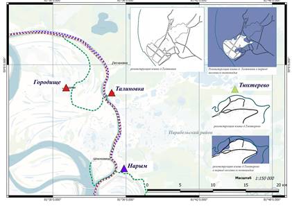
Drawing 1. Reconstruction of plans for small and medium-sized settlements of the Middle Ob region, the villages of Talinovka and Tyukhterevo. a) low-water period; b) high-water period
Within the boundaries of the unique settlement system, due to hydrological conditions, an equally unique structure of transport communication has been formed, which consists of three seasonal levels - summer, winter and off–season. With significant territorial boundaries of the spatial spot of the Middle Ob region, it is necessary to understand that the time spent on overcoming the distance from point A to point B varies greatly depending on the season. Field studies conducted by the author in 2017, 2018 and 2021 allowed us to confirm the described hydrological and climatic conditions in which the historically established settlement system is organized. The second block of materials in determining the main directions of studying the settlement system was made up of historical maps of the XVII – XX centuries, which are stored in central and local archives: the Russian State Historical Archive (RGIA), the Russian State Military Historical Archive (RGVIA), the State Archive of the Tomsk Region (GATO), the Center for Documentation of the Modern History of the Tomsk Region (CDNITO), the State Archive of the Novosibirsk region (GANO). Special attention is paid to the legislative framework: decrees of the Full Collection of laws of the Russian Empire, documents of the Embassy Order, articles of the Construction Charter, other state-level documents related to Siberia. The works of researchers who were based on historical documents related to settlement systems were taken into account. Facsimile editions of the Service Drawing Book and the Chorographic Book became the main source base for "immersion" in the XVII century. Another important source, I consider it necessary to indicate appendices to modern editions of S.U. Remezov's atlases, made as readings of atlases using a "modern" language. These works made it possible to rely on professional linguistic translations and focus on the study of the nature of the formation of the settlement system [4, 5, 6]. To date, the fundamental work of L.A. Goldenberg, dedicated to S.U. Remezov, has not lost its relevance. It was L.A. Goldenberg who presented S.U. Remezov's activity in compiling atlases as a unique experience of the national cartographic school. In the works of historians of cartography, the legacy of S.U. Remezov occupies an ambiguous place: some consider his work primitive, others note the practicality of hand-drawn drawings, their informativeness, diverse content. The publication of facsimile editions of the Chorographic Book of Siberia and the Official Drawing Book of Siberia by S.U. Remezov made the legacy of the cartographer of the XVII century available to a wide range of researchers. His atlases and books are used in historical, ethnographic, historical and architectural research, in the widest range of fields of science, concerning not only territorial research in Siberia and the Urals, but also the study of symbols, symbolism. The third block of materials, which determined the main directions of the research presented in this publication, consists of the author's field studies. Expedition 2017 in the village of Narym, it allowed to study in detail the process of transformation of the natural landscape and the "flushing" of three historical streets of the settlement by the river. The 2018 scientific expedition to the territory of the Middle Ob region was carried out within the framework of the RFBR grant 18-012-00464 "Urban planning retrospective of small and medium-sized settlements of the Ob-Yenisei Waterway". The route of the expedition ran through the territory of three administrative-territorial districts of the Tomsk region: Kolpashevsky, Parabelsky and Kargasoksky. The total length of the route is 1475 km, of which: along the Ob River and tributaries 319 km; overland routes – 156 km. The period of the expedition, June 18–July 09, 2018, was chosen based on the priority characteristics of the water regime: high water, water outflow from the intertidal channel and floodplain flooding. The collected full-scale materials formed the basis of this study, namely the planography of the following settlements: Parabel, Narym, Shpalozavod, Talinovka, Tyukhterevo, Peschanovka, Gorodishche, Kargasok, Pavlovo, Arable land, Neftyanikov, Geological, 5th kilometer, Bondarka, Slogan, Novoyugino, Staroyugino, Bolshaya Griva, Ust-Staritsa, Kazaltsevo, Tymsk, Ust-Tymsk, Vertikos, Karga, Kindal, Shchyuchy Cape, Mizurkino, Maly podelnik, Sosnovka, Vostok, Lugovskoye, Alataevo, Kopylovka (Figure 2). The process of collecting primary information during the passage of the expeditions was carried out with the involvement of terrain surveys from the three main satellite systems Bing, Yandex and Google as the main source of information. The totality of the information received allowed us to suggest that the study of the principles of the settlement system and localization of settlements on the territory of the Middle Ob region should be carried out in a complex and in the context of the entire water system of the region. 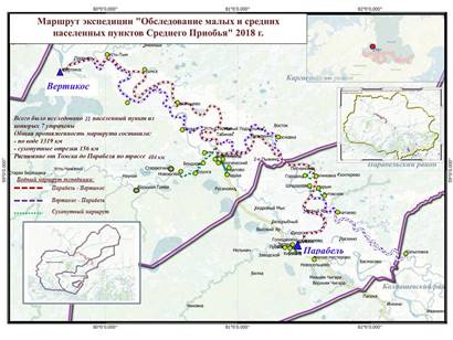
Drawing 2. Route "Survey of small and medium-sized settlements of the Middle Ob region 2018 The main part. Having a significant material and source base based on the statement of hydrographic and climatic conditions, graphoanalytic analysis of historical cartography and materials collected in the course of field studies, it became possible to identify the following directions of the process of studying the principles of settlement and localization of small and medium-sized settlements of the Middle Ob region. With confidence , we can single out a historical stage in the process of exploring these territories of the XVI century. to the end of the XIX century. At this stage, against the background of the natural development of the settlement system, as an organic structure serving the transport infrastructure of waterways and elements of overland drags connecting the basins of Siberian rivers in the latitudinal direction with each other, geographical data is recorded and described by scientists, travelers, and traders. The main works are written monuments of the national socio-economic, political, diplomatic and military history, as well as the history of the Russian Church for 1334-1700, published by the Archeographic Commission in 1841-1842 in St. Petersburg. This information resource is available for free use in the project "Runivers.ru – Russia in the original" [7]. Most of the works published on the resource are historical notes of travelers of the XVII–XVIII centuries. Thanks to these works in the middle of the XVIII century . there is a research base on the geography of Russia, including the territory of Western Siberia. Of particular value are the materials of the first scientific expeditions collected by G.F. Miller, D.G. Messerschmidt, F.I. Stralenberg, P.S. Pallas, I.G. Gmelin, I.G. Georgi, I.P. Falk, which describe water and land routes in Siberia, as well as settlements included in the transport infrastructure.
More detailed information about settlements located in the structure of the waterway along the Ob River is given in the work of N.I. Novikov, which was first published in the second half of the XVIII century, and it can be found on the resource "Runivers.ru – Russia in the original." The work contains a brief description of maps made at the end of the XVII century, classification of large and small rivers of Russia, including the Ob River basin, with names and enumeration of settlements according to officials who visited there. The works of the XVIII century are mainly descriptive in nature, contain information that allows you to refine data on the location and toponymy of populated places located on the banks of the Ob River. In the descriptions of settlements, data on the features of development and the nature of the activities of the local population are given. Until the second half of the XIX century, no serious statistical works on urban planning of the Siberian region were revealed, therefore, in many respects, the studies of Siberia are of an evaluative nature, assuming and creating hypothetical reconstructions of individual elements of the settlement system of small and medium-sized settlements of the Middle Ob region until the XIX century. Thus, historical sources do not have a research component and a systematic assessment of the settlement system, and at present they themselves are sources and material evidence. A separate and massive block of research consists of biological, ecological, geological, etc. descriptions of the natural-climatic and landscape conditions of the Middle Ob region, conducted by the geographical and botanical schools of TSU (Shumilova, 1962; Atlas of Tyumen, 1971; Vegetation cover, 1985, etc.). It is their long-term observations of the botanical composition of the vegetation layer, soils, continental soils that allow us to draw conclusions about economic activity in the floodplain territory of the Ob in the middle current. Urban planning studies of settlement systems located in these territories have not been identified. It is possible to mention only the works of V.F. Boldyrev, who wrote a textbook on the basics of urban planning in Western Siberia, however, regional specifics in his work are not singled out as a key factor influencing the settlement system [8]. It is necessary to highlight the works devoted to the study of the principles of settlement and localization of settlements in general - economic geography and urban planning theory are engaged in this. The main developments in these areas are formulated in terms of the basic framework of settlement. The theory of the basic framework of settlement was formulated in the works of N.N. Baransky, N.N. Kolosovsky, I.M. Mayergoiz, Yu.G. Saushkin, G.M. Lappo, and was used mainly for the concepts of territorial development of agglomerations based on the division of labor [9, 10, 11, 12, 13]. It is important to note that this field of knowledge is quite young and the main works date back to the 70s of the XX century. A significant part of the works is written on the basis of the analysis of the "European" material of Russia, and the territory of Western Siberia is considered only in the context of this material. In general, the study of the phenomenon of the city was studied in detail at the turn of the XIX–XX centuries, when most of the then low-rise large administrative-territorial centers of the whole world faced the problem of further territorial development. It was then that intellectuals in the field of architecture and urban planning, together with politicians, made an important strategic decision, what should the cities of the future be? where should they develop – in breadth or up? This is how two concepts were formulated: urbanization and deurbanization. After the Second World War, the polemic between the two polar approaches in the organization of space and the development of settlement systems was replaced by the final dominance of urbanists. I would like to emphasize that these concepts are not just polar, they represent an extreme polarity in the way of thinking. The dominance of urbanists also affected the assessment of the processes of historical development of settlement structures, which were artificially included in a kind of conditional paradigm of the evolutionary development of the city, reflecting the stages at the extreme point of which the settlement system becomes a modern agglomeration. This concept formed the basis of the industrialization of our state in the 20s-30s of the XX century, and on the basis of economic achievements took a dominant position. Currently, this field of knowledge considers a set of approaches and forms of interactions within each individual agglomeration and their external interaction from the standpoint of the hierarchy of systems. In this publication, the history of the development of the settlement system is considered within the framework of the deurbanization concept of settlement. Studies considering the settlement system of small and medium-sized settlements from the standpoint of their self-sufficiency, the effectiveness of the organization of economic activity has not been revealed. The medieval Russian city of the XV–XVII centuries is widely studied, it is in these studies that the city is considered as a unique system of territorial organization of space, harmoniously integrated into the lines of the natural landscape. Among the modern theorists in the field of urban history, it is necessary to mention I.A. Bondarenko, who in his publications "On the organic in urban Planning", "On the naturalness of agglomeration formation", "Manor and City in Ancient Russia", "The idea of hierarchy in the architecture of Ancient Russia", etc., reveals the phenomenon of the ancient Russian city [14]. The transformation of the planning structure of the city of the X–XV centuries is considered by A.S. Schenkov, whose ideas are consonant with the founders of the theory of urban art: L.M. Tversky, A.V. Bunin, N.F. Gulyanitsky, A.V. Ikonnikov, T.F. Savarenskaya, P.A. Rappoport, etc. [15, 16, 17, 18, 19, 20, 21]. One of the first works on the Russian city was the research of G.V. Alferova, which still remains relevant today [22]. The above-mentioned scientists are the founders of the history of urban art and consider the medieval city as an identity, as a phenomenon that has passed into the past. Russian Russian Russian city These works determine the directions in the study of the phenomenon of the Russian city, they are attracted to the territory of the Middle Priobye on the basis that the Middle Priobye was an integral part of Russian culture and had an inextricable transport connection with the Russian North. The closest to the problem of determining the nature of the organization of the planning structure of small and medium-sized settlements are the works devoted to the analysis of planography and the study of processes accompanying the development of the architectural and planning fabric of the city. It is necessary to single out an extensive block of authors dealing with various aspects of the socio-political life of small and medium–sized settlements within the boundaries of the Tomsk province of the XVII - XIX centuries, among them: Boyarshinova Z.Ya., Dmitrienko N.M., Kirichenko E.I., Petrov N.M., Popov A.I., etc. [23, 24, 25, 26, 27]. Graphical analysis of the planning structure of the city of Tomsk of the XVII–XX centuries makes it possible to trace the stages of development of the natural landscape in the process of development of the settlement from small to medium, and then to large [28].
If urban art theorists talk about settlements through the prism of graphical analytics of their planning structure and spatial characteristics of the city-forming elements, then the work of archaeologists allows you to delve into details, fragments, elements, allow you to touch the material history, the one that can be viewed and touched. Archaeological finds can be confidently identified in a separate block of relevant research areas conducted on the territory of the Middle Ob region. It is they who prove the presence of the oldest culture on these lands, some of which date back to the X – III centuries BC. For the study of settlement systems, the geographical location of famous archaeological finds from the excavations of the Ob region itself is important. Among the most studied and described archaeological sites on the territory of the Middle Priobye are: Medvedkin finds, Malokirgiz complex, Belyai find from Prichulymye, Ishim treasure, Ust-Kindinsky kurgan burial ground, Timiryazevskoye-I settlement, Murlinsky treasure, a find from the Konda River, Barsovsky-VII burial ground, Barsov Gorodok II/6 settlement, Biysk settlement-6, Ust-Poluy settlement, a find from Kudryashovsky Forest, Negotskoye-VI settlement, Vasyugansky "treasure", Tiutey-Sale settlement-1, Third Cordon settlement-1, Third Cordon settlement-2, Timiryazevsky-II burial mound, Relka burial mound, Parabel cult place, Ust-Poluy settlement et al. [29]. The study of the medieval Siberian city as an integral organism, the center of concentration of social, economic and political aspects of society is reflected in the works of M.P. Chernaya [30]. It is in her writings that one can find a vivid description of the urban environment of the XVII century, filled with all sorts of qualities. Based on numerous excavations, she manages to prove the presence of dynamism in the historical space, instead of the well-established museum-based form of representation of archaeological objects. The works covering the history of the formation of transport communications are of no small interest. The whole complex of these studies is focused on the personalities who created these paths. Interesting are the studies devoted to the original roads that crossed the territory of the Middle Ob region, which were used from generation to generation. First of all, it is worth noting the works of S.V. Bakhrushin and O.N. Vilkov [31, 32]. In these works, the settlement system is considered in the context of the formation of the state postal service, the organization of the prisoner staging process and open a different perspective on the processes of the functioning of the road. Although these works belong to a later period of time than the designated chronological framework of this study, they allowed us to look at the principles of the formation of the settlement structure along state roads. The history of the formation of the Yenisei Waterway makes it possible to comprehensively assess the importance of the river in the transport system of the state. It is necessary to note the research of Litvinova O.G., whose works are based not only on archival research, but also on field surveys of the territory [33]. With access to social aspects that are of decisive importance in the processes of formation, as elements of the settlement of small and medium-sized settlements as transport communications, a separate block of research is anthropological. The works of A.V. Golovnev, who actively studies the "anthropology of movement" [34], became the most consonant with the author. His works vividly illustrate the life of the nomads of the North, in his research by modern means of observation, he proves the viability of nomadic cultures. The most important for the current work is A.V. Golovnev's view on the assessment of the interaction of subcultures within the framework of the organization of mutual life activity within the boundaries of transport communication. Of interest are the works of L.I. Sherstova, which give an idea of the ethnographic picture in the upper reaches of the Ob River. The works of ethnographers Shatilova M.B., Kulemzin V.M., Alekseenko E.I., etc., give ideas about the economic life of the peoples living in the latitudes of interest to us [35, 36, 37, 38]. Conclusions Thus, no special urban planning studies considering the system of settlement and localization of settlements in the Middle Ob region have been identified. Relatively studied is the historical aspect of the period of the XVIII century, which has material and written evidence of travelers. The situation is completely different from the XVII century, the lack of data forces us to build research on indirect and later sources. On the one hand, we can confidently talk about the huge work done to date, on the other hand, there is an understanding that the process of development and the settlement system itself in these territories requires a new reading, using methods of cross-cultural communication with the involvement of geoinformation systems. It is necessary to make an appeal to the historical experience of settlement of the colonization era, when a network of settlements formed in Siberia from cities, prisons, rural settlements, settlements, settlements, which successfully functioned until the XXI century. It is important to critically analyze the process of introducing a modern approach to the development of territories, when large centers dominate due to the degradation of small and medium-sized ones. The available cartographic sources of the XVII–XX centuries indicate a developed settlement system in this territory, as well as its inclusion in the world communication network. In this article, based on the analysis of the main research directions, the insufficiency of the unique historically established settlement system in the territory of the Middle Ob region has been proved, which led to ambiguous transformations in the reform of the administrative-territorial system. It is necessary to raise the issue of conducting a special in-depth study of the principles of settlement and localization of small and medium-sized settlements on the territory of the Middle Ob region by urban planning specialists.
References
1. On the approval of the Spatial Development Strategy until 2025 [Ob utverzhdenii Strategii prostranstvennogo razvitiya do 2025 goda] : the decree of the Government grew. Federations. Government of Russia : official website. URL: http://static.government.ru/media/files/UVAlqUtT08o60R ktoOXl22JjAe7irNxc.pdf/ (data of treatment: 10.03.2022). (rus)
2. Efimenko, S. V., Badina, M. V. (2015). Taking into account the peculiarities of natural and climatic conditions in the road and climatic zoning of the territory of Western Siberia. In Vestnik of Tomsk State University of Architecture and Building 2 (49) (pp. 204-213).
3. Comprehensive monitoring of the Great Vasyugan swamp: current state and development processes under the influence of natural and anthropogenic factors. URL: http://www-sbras.nsc.ru/HBC/2001/n18-19/f18.html (data of treatment: 10.03.2022).
4. Remezov, S. U. Chorographic Drawing Book of Siberia by S. U. Remezov. Tobolsk : Tobolsk Renaissance Foundation.
5. The Book is A Large Drawing (1950). Moscow : Publishing House of the Academy of Sciences of the USSR
6. Remezov, S. U. Drawing Book of Siberia (2003): Comp. Tobolsk son boyar Semyon Remezov in 1701 Feder. Geodesy and Cartography Service of Russia. Vol. 1. 48 p.
7. Runivers Electronic Encyclopedia and Library [E`lektronnaya e`nciklopediya i biblioteka Runivers]. URL: https://runivers.ru/gal/maps.php (data of treatment: 10.03.2022). (rus)
8. Boldy`rev V. F. Fundamentals of urban planning in Western Siberia [Osnovy` gradostroitel`stva v usloviyax Zapadnoj Sibiri]. Tomsk. 1991. 160 p. (rus)
9. Baranskij N. N. About the economic and geographical study of cities [Ob e`konomiko-geograficheskom izuchenii gorodov]. Economic geography. Economic cartography. Geografgiz. 1957. Pp. 166–182. (rus)
10. Kolosovskij N. N. Economic zoning of productive forces in connection with the development of the transport network of the USSR [E`konomicheskoe rajonirovanie proizvoditel`ny`x sil v svyazi s razvitiem transportnoj seti SSSR]. Geography issues. 1972. Pp. 36-52 (rus)
11. Maergojz I. M. The territorial structure of the national economy and some approaches to its use in the light of socialist integration [Territorial`naya struktura narodnogo xozyajstva i nekotory`e podxody` k ee ispol`zovaniyu v svete socialisticheskoj integracii]. Geography. 1975. No. 4. Pp. 3–21. (rus)
12. Saushkin Yu. G. Economic geography: history, theory, methods, practice [E`konomicheskaya geografiya: istoriya, teoriya, metody`, praktika]. Education. 1976. 559 p. (rus)
13. Lappo G. M. The concept of the supporting framework of the territorial structure of the national economy: development, theoretical and practical significance [Koncepciya opornogo karkasa territorial`noj struktury` narodnogo xozyajstva: razvitie, teoreticheskoe i prakticheskoe znachenie]. Izvestia of the USSR Academy of Sciences. The series is geographical. 1983. No. 5. Pp. 16–28 (rus)
14. Bondarenko I. A. Theory in the history of architecture and urban planning [Teoriya v istorii arxitektury` i gradostroitel`stva]. St. Petersburg : Kolo. 2017. 832 p. (rus)
15. Shhenkov A. S. Some features of the composition of the cities of the Russian North of the XV-XVII centuries [Nekotory`e osobennosti kompozicii gorodov russkogo severa XV–XVII vv]. Architectural heritage. 1979. No. 27. 22–29 p. (rus)
16. Tverskoj L. M. Russian urban planning until the end of the XVII century [Russkoe gradostroitel`stvo do koncza XVII veka]. State Publishing house lit. by builds. and architecture. 1953. 215 đ. (rus)
17. Bunin A. V. History of urban planning art [Istoriya gradostroitel`nogo iskusstva]. State Publishing house lit. on construction and architecture. Vol. 1: The slave-owning system. Feudalism. Capitalism. 1953. 532 p. (rus)
18. Russian Urban Planning art: Ancient Russian urban planning [Russkoe gradostroitel`noe iskusstvo: Drevnerusskoe gradostroitel`stvo]. Moscow, 1993 (rus)
19. Čęîííčęîâ Ŕ. Â. Ňűń˙÷ŕ ëĺň đóńńęîé ŕđőčňĺęňóđű. Ě., 1990. Ikonnikov A.V. A thousand years of Russian architecture [Ty`syacha let russkoj arxitektury`]. Moscow, 1990 (rus)
20. Savarenskaya T. F. The history of urban art: slaveholding and feudal periods [Istoriya gradostroitel`nogo iskusstva : rabovladel`cheskij i feodal`ny`j periody`]. Moscow, 1984 (rus)
21. Rappoport P. A. About the typology of ancient Russian settlements [O tipologii drevnerusskix poselenij]. Brief reports of the Institute of Archaeology. 1967. Vol. 110. Pp. 3–9 (rus)
22. Alferova G. V. Russian cities of the XVI-XVII centuries [Russkie goroda XVI–XVII vekov]. M.:Stroyizdat, 1989. – 210 p. (rus)
23. Boyarshinova Z. Ya. Population of Western Siberia before the beginning of Russian colonization [Naselenie Zapadnoj Sibiri do nachala russkoj kolonizacii]. Tomsk, 1960 – 149 p (rus)
24. Dmitrienko N. M. Day after day, year after year: chronicle of Tomsk life in the XVII-XX centuries [Den` za dnem, god za godom: xronika zhizni Tomska v XVII–XX stoletiyax]. Tomsk, 2003. – 346 p (rus)
25. Kirichenko E. I. Wooden architecture of the Russian city and architecture of Tomsk [Derevyannoe zodchestvo russkogo goroda i arxitektura Tomska]. Wooden architecture of Tomsk. Soviet artist. 1987. – 115–146 Pp (rus)
26. Petrov N. M. The experience of restoring the plan of the Tomsk city and the prison of the beginning of the XVII century [Opy`t vosstanovleniya plana Tomskogo goroda i ostroga nachala XVII v.]. Proceedings of the Tomsk region. local historian. ěuseum, 1956. Vol.5. 59–78 Pp. (rus)
27. Popov A. I. Tomsk [Tomsk]. Gosstroyizdat, 1959. 132 p. (rus)
28. Voronina O. S. The history of urban development of the city of Tomsk in the XVII-XX centuries [Istoriya gradostroitel`nogo razvitiya goroda Tomska v XVII–XX vv.]. Vestnik of Tomsk State University of Architecture and Building. 2016. No 1 (54). Pp. 91-106. (rus)
29. Ob region through the eyes of archaeologists and ethnographers: Materials and research for the "Encyclopedia of the Tomsk region" [Priob`e glazami arxeologov i e`tnografov: Materialy` i issledovaniya k «E`nciklopedii Tomskoj oblasti»]. Tomsk, 1931 (rus)
30. Chyornaya M. P. The role of the Russian city in the Development of Siberia: the Dialectic of possibilities and historical practice [Rol` russkogo goroda v osvoenii Sibiri: dialektika vozmozhnostej i istoricheskoj praktiki]. Russian Culture in Archaeological research: interdisciplinary methods and technologies. Omsk, 2011. 7–16 Pp (rus)
31. Bakhrushin S. V. Siberia and Central Asia [Sibir` i Srednyaya Aziya] Scientific works. M. : Nauka, 1959. Vol. 4: Essays on the history of the Krasnoyarsk district in the XVII century. Siberia and Central Asia in the XVI-XVII centuries. 1959. 198–212 Pp. (rus)
32. Vilkov O. N. Bukharans and their trade in Western Siberia in the XVII century [Buxarcy i ix torgovlya v Zapadnoj Sibiri v XVII v]. Siberia to the XVI – beginning . XX century. Tomsk, 1987. 171– 214 Pp (rus)
33. Litvinova O. G. Ob-Yenisei Canal: engineering and technological aspect [Ob`-Enisejskij kanal: inzhenerno-texnologicheskij aspekt]. Tomsk State University of Architecture and Building. 2018. – 187 p (rus)
34. Golovnev A.V. Speaking cultures : Traditions of Samoyeds and Ugrians [Govoryashhie kul`tury` : Tradicii samodijcev i ugrov]. Ekaterinburg, 1995. – 606 p. (rus)
35. Sherstova L. I. Ethnopolitical history of the Turks of Southern Siberia in the XVII-XIX centuries [E`tnopoliticheskaya istoriya tyurkov Yuzhnoj Sibiri v XVII–XIX vv]. Tomsk, 1999. 432 p (rus)
36. Shatilov M. B. Vakhovsky ostyaks : (ethnographic essays) [Vaxovskie ostyaki : (e`tnograficheskie ocherki)]. Tomsk, 1931. 175 p (rus)
37. Kulemzin V. M. Vasyugansk-Vakhov Khanty in the late XIX-early XX centuries : Ethnographic essays [Vasyugansko-vaxovskie xanty` v konce XIX – nachale XX vv. : E`tnogr. ocherki]. Tomsk, 1977. 225 p (rus)
38. Alekseenko E. A. Kety: Historical and ethnographic essays [Kety`: Istoriko-e`tnograficheskie ocherki]. The science. 1967. 260 p (rus)
Peer Review
Peer reviewers' evaluations remain confidential and are not disclosed to the public. Only external reviews, authorized for publication by the article's author(s), are made public. Typically, these final reviews are conducted after the manuscript's revision. Adhering to our double-blind review policy, the reviewer's identity is kept confidential.
The list of publisher reviewers can be found here.
The article presented for publication "The main directions in the process of studying the principles of settlement and localization of small and medium-sized settlements in the territory of the Middle Ob region" is a full-scale and historical study of the experience of the formation and further functioning of the settlement system in small and medium-sized cities in the territory of the Ob region since the XVII century. The subject of the study correlates with the purpose of the study, and follows from the paragraph: "... which will allow us to identify the key parameters of the settlement system for their further integration into the legal field of the Russian Federation." The research methodology is widely and clearly presented: "The general scientific principle of historicism is used as the main method, ...", "The method of architectural and restoration analysis is used, including field research, architectural measurements, systematization of archival documents, drawings, antique photographs and statistical information." The approaches and principles of the study are also objectively outlined: "A systematic approach allowed to attract a wide range of sources and comprehensively assess the conditions for the formation of transport communications and its infrastructure", "The principle of objectivity is applied to compare (compare) data, ...". The relevance of the study is: "...[the article] is devoted to substantiating the need for a separate study aimed at studying the principles of settlement and localization of small and medium-sized settlements in the territory of the Middle Ob region ... adopted by the government of the Russian Federation on February 13, 2019. The Strategy of Spatial Development of the Russian Federation for the period up to 2025, which defines the main trends and positions in the process of territorial development of the state. The following is a link to the source. Scientific novelty is not represented. The style is scientific, corresponds to the normalization of speech, facts are accurately and fully explained, cause-and-effect relationships in concepts are shown. The structure of the text is correct, the structural elements of the text are present in the study. Contents: the study presents an introduction, methods and methods of research, the main part ("Materials and source base consist of several blocks: the first and fundamental are the geographical characteristics of the territory of the Middle Ob region, the second are historical maps of different times of the XVII – XX centuries. and historical documents, the third is the author's field studies") and the conclusions of the study. The paper contains 2 figures compiled by the authors of the article. The research of the bibliography on this topic is presented by sources, among them there are: 37 Russian authors and 1 reference to a normative document. References to foreign authors are not provided. The paper presents an extensive appeal to opponents: 1) the works of L.A. Goldenberg devoted to the editions of atlases by S.U. Remezov; 2) Materials of the first scientific expeditions collected by G.F. Miller, D.G. Messerschmidt, F.I. Stralenberg, P.S. Pallas, I.G. Gmelin, I.G. Georgi, I.P. Falk; 3) information about settlements located in the structure of the waterway according to R. Ob, it is given in the work of N.I. Novikov, etc. The presented conclusions correspond to the objectives of the study. Comments on the work: In the paragraph: "I consider it necessary to indicate appendices to modern editions of atlases as another important source ..." the use of personal pronouns is unacceptable. In the sentence "The total length of the route is 1475 km ..." a space is needed between the words. The article is intended for a wide range of readers interested in the formation of settlement systems, urban planning studies that comprehensively consider the system of settlement and localization of settlements. From the point of view of architecture and urban planning, the article will arouse the reader's interest among students of architectural universities, various figures in the field of historiography, archival affairs, engineers, practitioners in the field of urban planning and cartography, architects. Conclusion: the work meets the requirements for scientific presentation and is recommended for publication.
|

 Eng
Eng


